


 Art & Design
 Auto & Vehicles
 Beauty
 Business
 Education
 Entertainment
 Finance
 Food & Drink
 Health & Fitness
 House & Home
 Libraries & Demo
 Lifestyle
 Maps & Navigation
 Medical
 Music & Audio
 Parenting
 Personalization
 Photography
 Productivity
 Shopping
 Social
 Sports
 Tools
Tools Travel & Local
 Video Players
 Weather
 Family


 Topo Maps US
OS :
Version :6.4
Size :12.76Mb
Updated :Sep 26,2022
Developer :David Crawshay
 Ask AI
You can ask
the AI some questions about the app
Here are three topics related to the Topo Maps US app, turned into questions:
1. How easy is it to find your location using the app's offline mapping feature?
2. Can you customize the map display to show only the information you need?
3. Are the maps regularly updated to reflect changes in the terrain, roads, and trails?
 Ask AI
Pros and Cons from users' feedback
After analyzing the users' reviews on the Topo Maps US app, I've extracted the following conclusion:
**Cons:**
1. Limited offline map availability: Many reviewers experienced issues with limited offline map serveding.
2. Steep learning curve: Some users found it difficult to navigate the app's interface and features.
3. Occasional crashes: A few reviewers reported occasional crashes and errors while using the app.
**Pros:**
1. Accurate topographic maps: Users praised the app's accurate and detailed topographic maps.
2. Offline navigation: Many reviewers appreciated the app's ability to provide offline navigation.
3. Essential for outdoor enthusiasts: Topo Maps US is considered a valuable resource for hikers, campers, and outdoor enthusiasts.
Please note that it's essential to keep in mind that these are general conclusions based on the reviews, and individual experiences may vary.
App
Downloads
<
>
App
Survey
-
What is your Mobile System?
-
Where do you get the new APP
-
The degree of memory and power consumption Does it affect the experience?
-
Do you think the payment of application features affects the experience?
Description
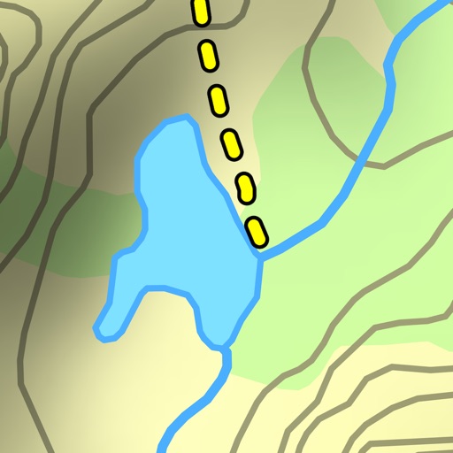
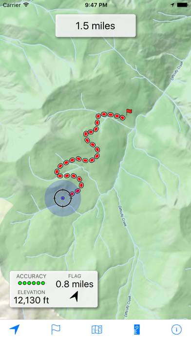
Download and view topographic maps covering the United States.
Topographic maps are useful for recreational activities such as hiking, canoeing, camping, fishing, mountain biking, geocaching, and exploring.
MAPS
Choose from 2 map sources: USGS standard topographic or USGS hybrid topographic.
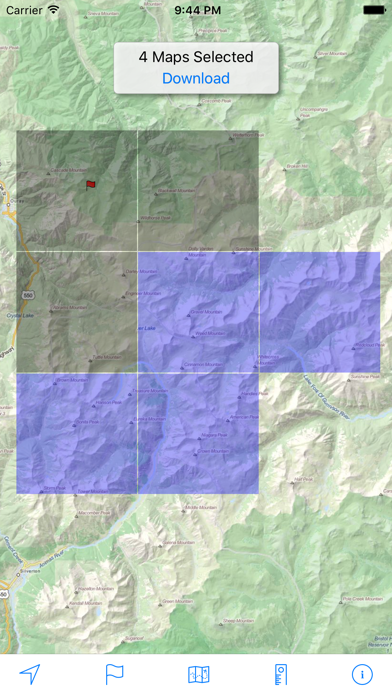
OFFLINE
Download maps for areas of interest to view them later when you don't have Internet access or you don't want to use cell data.
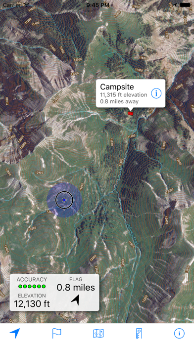
TRACKING
Use location tracking to show where you are on the map, your elevation, and the accuracy of the GPS signal.
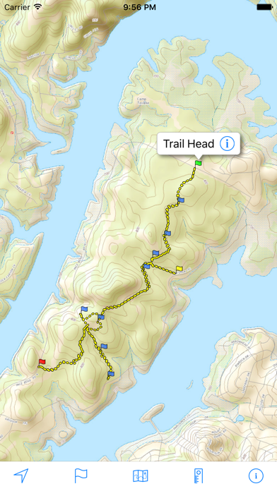
FLAGS
Flags are included with map downloads. Add flags (waypoints) to the map to mark your current location or other locations. Import flags from other sources using GPX files and geocache LOC files. Share flags with others using email or AirDrop. Organize your flag types by color, for example, geocaches, trailheads, and summits.
TRAILS
Trails are included with map downloads. Import trails (tracks) using GPX files you find on the Internet or from your personal GPS track collection. Share trails with others using email or AirDrop. Organize your trail types by color, for example, mountain bike trails, hiking trails, and OHV trails.
TRAIL RECORDING
Record your own trails to show where you've been on the map, follow them later, and share with others.
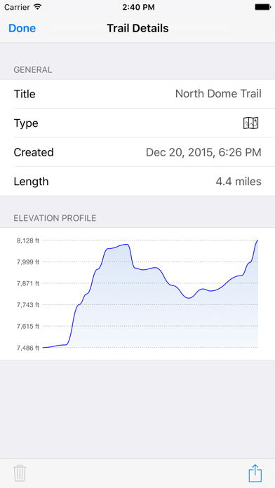
ELEVATION PROFILE
Recorded trails include an elevation profile (distance/elevation chart).
NAVIGATION
Navigate to a flag by following the direction arrow that uses your compass heading. Useful for geocaching.
MEASURE
Measure the distance between points on the map.
Note: Continued use of GPS running in the background can dramatically decrease battery life.
{{descriptionMoreText}}
Comments (2)
{{commentText.length}}/{{maxCommentText}}
{{commentError}}{{commentUserError}}
-
{{comment.commentUser.substring(0, 1)}}By {{comment.commentUser}}{{comment.commentDateString}}
-
SBy SkadamInTorontoJul 28,2017
-
YBy YYC650Mar 23,2016
Developer apps

Category Top
apps
- Google Play
- App Store


More Apps


