


 Art & Design
 Auto & Vehicles
 Beauty
 Business
 Education
 Entertainment
 Finance
 Food & Drink
 Health & Fitness
 House & Home
 Libraries & Demo
 Lifestyle
 Maps & Navigation
 Medical
 Music & Audio
 Parenting
 Personalization
 Photography
 Productivity
 Shopping
 Social
 Sports
 Tools
Tools Travel & Local
 Video Players
 Weather
 Family


 Maps 3D - Outdoor GPS
OS :
Version :6.3
Size :24.71Mb
Updated :Oct 8,2021
Developer :movingworld GmbH
 Ask AI
You can ask
the AI some questions about the app
Based on online discussions about the app "Maps 3D Outdoor GPS", here are three topics and questions for you:
1. **GPS Accuracy**
Will the app provide reliable and accurate GPS directions in urban canyons and areas with limited satellite visibility?
2. **Offline Functionality**
Can I still use the app's mapping features and GPS tracking offline without reliance on cellular data or Wi-Fi connectivity?
3. **Additional Features**
Are there any notable additional features, such as traffic updates, weather forecasts, or points of interest, that make this app stand out?
 Ask AI
Pros and Cons from users' feedback
I'd be happy to help you with that! After analyzing the user reviews on the Apple App Store, here are three pros and three cons of the Maps 3D Outdoor GPS app:
Pros:
1. Accurate GPS tracking with real-time updates, even in remote areas.
2. User-friendly interface with clear navigation and easy-to-use features.
3. Offline mode allows for seamless navigation without internet connectivity.
Cons:
1. Some users experienced issues with map loading and slow performance.
2. Limited POI (Points of Interest) data and lack of detailed street views.
3. Occasional errors in route calculation and incorrect turn-by-turn directions.
Please note that these points are based on the user reviews and may not be exhaustive or entirely accurate. If you'd like me to clarify or expand on any of these
App
Downloads
<
>
App
Survey
-
Do you think the aesthetics of the interface UI affects the experience?
-
Does the update frequency of the application affect the experience?
-
Application technology innovation Does it affect the experience?
-
What is your Mobile System?
Description
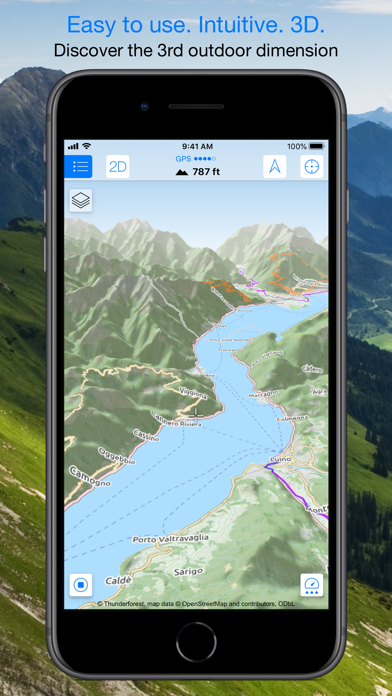
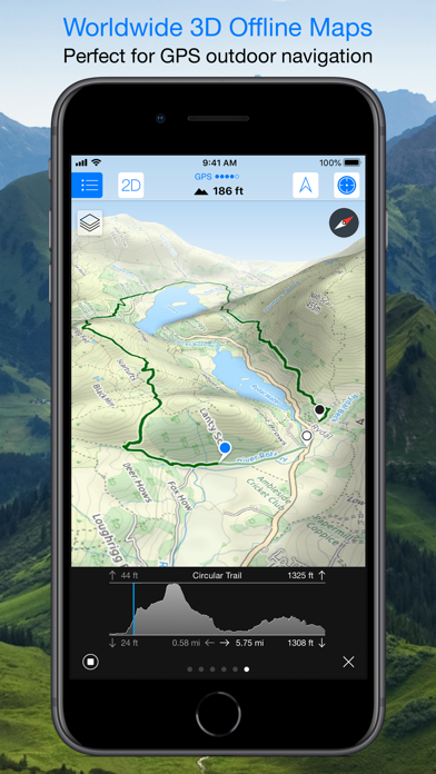
Enjoy exploring the great outdoors? If you’re a fan of biking, hiking and running then Maps 3D is the ideal app designed for planning your outdoor adventures. Whereas other mapping apps are primarily designed for cities and roads, displaying hills and mountains as flat and lifeless features, Maps 3D is packed with amazing features that brings the great outdoors to vibrant life with valleys, hills, mountains and footpaths displaying in full 3D so you’ll know your exact elevation.
*** Featured by Apple with a main banner in the US App Store Navigation category! (02/2013)
*** 3rd place at the '2013 Best App Ever Awards' by 148apps.com in 'Best Outdoors Apps'
*** Over 1,700,000 global users!
*** TOP 1 App in Navigation in 75+ countries (as of 01/2017)
*** "The functions are helpful; the compilation of 3D maps is impressive." Macwelt.de – Score: 1.8
*** "An app recommended for hikers, cyclists and horse enthusiasts..." iPhone & iPad apps in Test Magazine, issue 3/2011 – Score: 8/10
STORE ROUTES & USE OFFLINE
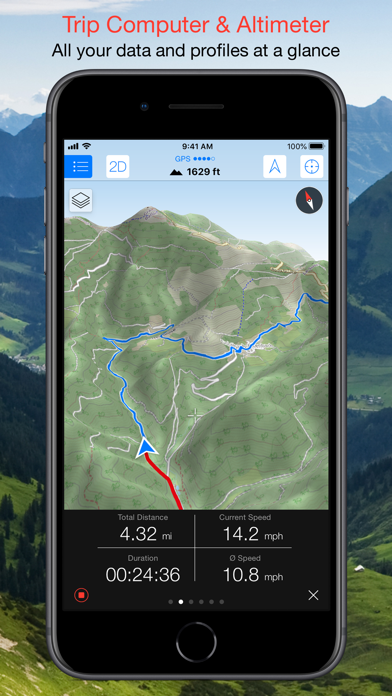
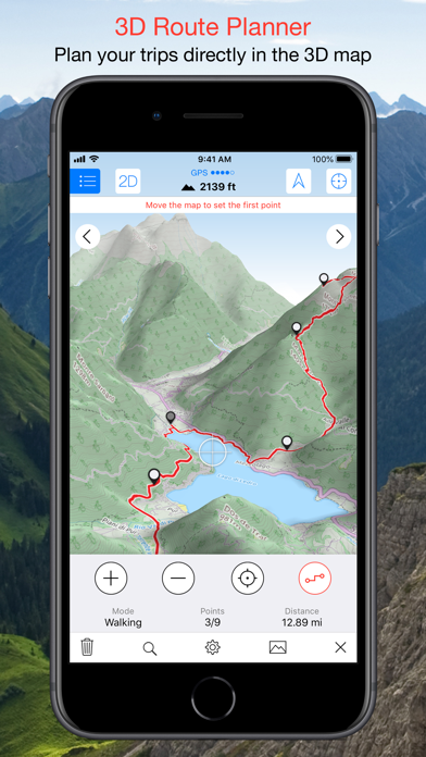
With Maps 3D you’ll have the option to plan, record and share your routes, turning your iPhone into a fully-fledged GPS device so you can log key coordinates and elevations. You’ll also have offline access to worldwide 3D map data which limits the drain on the battery and means that you can pre-load a map to store when you don’t have a signal.
SEARCHABLE MAPS
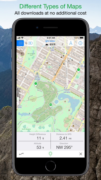
As an added bonus Maps 3D offers 3D terrain and trip planning, so you’ll never need to worry about getting lost. Towns, streets, mountain peaks and lakes are all searchable, with an accurate and precise map display based on NASA scans of the Earth’s surface combined with the outdoor map OSM (Open Street Map) and the Official USGS topo maps.
LOAD YOUR TRIPS & SHARE
Trips can be loaded via iTunes, email, URL or Dropbox, and recorded tracks can be shared via email, Facebook and Twitter, great for showing your friends your latest outdoor accomplishments.
MORE FEATURES
+++ Load a map in advance over WIFI or 4G before your trek, no internet connection needed thereafter
+++ Record your routes by GPS, all coordinates and exact elevations are logged
+++ Plan and evaluate routes directly in the 3D map view
+++ Search for towns, streets , mountain peaks, lakes - offline
+++ Distance traveled, current and average speeds all displayed for an ideal trek
GENERAL / NOTES
Background GPS recording can significantly cut battery life
* * * * *
If you like Maps 3D, please remember to leave a positive rating on iTunes!
The movingworld team is working constantly to improve Maps 3D. Any suggestions? We'd love to hear them! Just e-mail them to us at [email protected]. We'll try to answer you within 24 hours!
Thank you for using Maps 3D!
{{descriptionMoreText}}
Comments (3)
{{commentText.length}}/{{maxCommentText}}
{{commentError}}{{commentUserError}}
-
{{comment.commentUser.substring(0, 1)}}By {{comment.commentUser}}{{comment.commentDateString}}
-
ABy AlexeikzJan 31,2012
-
KBy Kevin_in_csAug 23,2019
-
HBy HalfGlassFullFeb 5,2021
Developer apps
Category Top
apps
- Google Play
- App Store


More Apps


