


 Art & Design
 Auto & Vehicles
 Beauty
 Business
 Education
 Entertainment
 Finance
 Food & Drink
 Health & Fitness
 House & Home
 Libraries & Demo
 Lifestyle
 Maps & Navigation
 Medical
 Music & Audio
 Parenting
 Personalization
 Photography
 Productivity
 Shopping
 Social
 Sports
 Tools
Tools Travel & Local
 Video Players
 Weather
 Family


 River Levels & Flows
OS :
Version :1.1.10
Size :24.16Mb
Updated :Dec 5,2021
Developer :LW Brands, LLC
 Ask AI
You can ask
the AI some questions about the app
Here are three topics that users of the River Levels & Flows app might discuss online:
1. Are the flood warnings on the app reliable and prompt?
2. How accurate are the river level predictions on the app?
3. Are there any offline features on the app or do I need internet connection?
 Ask AI
Pros and Cons from users' feedback
Based on the users' reviews of the River Levels & Flows app, here are three pros and cons:
**Pros:**
1. Easy to use with a clean interface, allowing users to quickly access river level data. (15 words)
2. Provides accurate and real-time river level information, making it a valuable resource for planning and safety. (15 words)
3. Offers a wealth of data on river flows, weather conditions, and water levels, making it a comprehensive tool. (15 words)
**Cons:**
1. Some users find the app's layout and navigation confusing, leading to frustration. (15 words)
2. Limited coverage of rivers and streams, leaving out many popular waterways. (15 words)
3. App can be slow to update, causing delays in accessing current river level information. (15 words)
Please note that these conclusions are based on the reviews available on the App Store and may not accurately represent the app's overall performance.
App
Downloads
<
>
App
Survey
-
How much traffic the app consumes Does it affect the experience?
-
Application technology innovation Does it affect the experience?
-
Application interactivity Does it affect the experience?
-
Do you think the payment of application features affects the experience?
Description
Main Features Include:
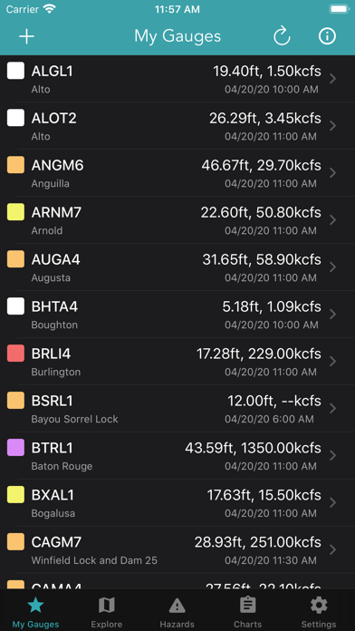
+ USGS / AHPS River Levels & Flows
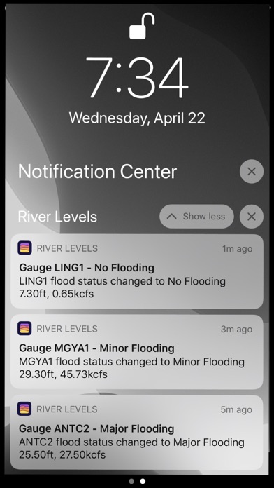
+ Gauge Flood Status Push Notifications
+ Weather Prediction Center Charts
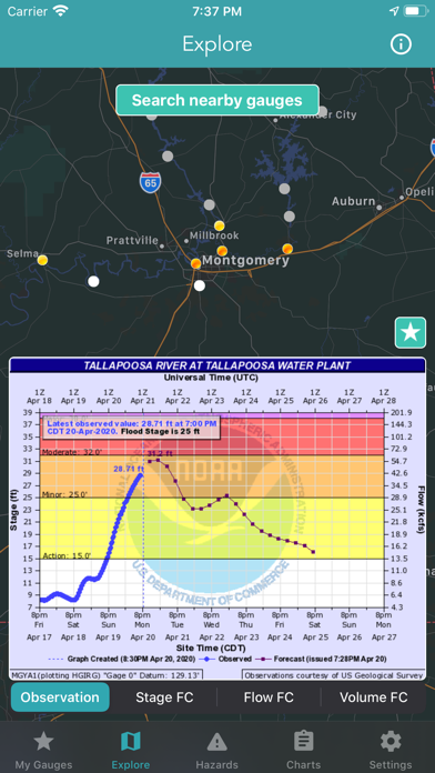
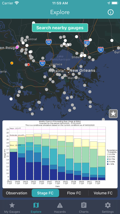
Interactive USGS / AHPS Gauge Map
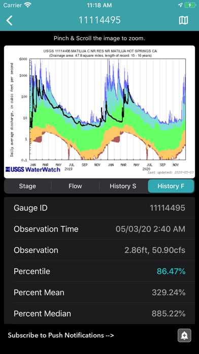
The USGS maintains a national network of stream gauges that provide hydrological observations. In addition, AHPS collects real-time water level information from other federal, state, and local stream gauge networks.
USGS / AHPS Hydrological Data Includes:
+ Water Level & Flow Observations
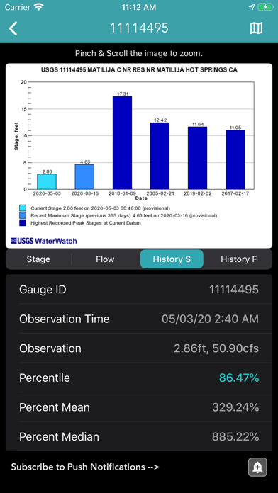
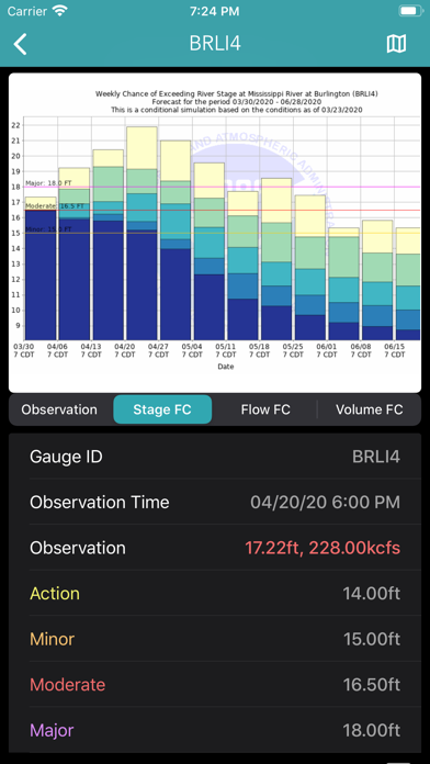
+ Gauge Levels, Flows & Volume Forecast
+ Gauge History & Statistics
+ Flood Status Push Notifications
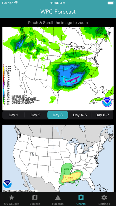
Weather Prediction Center Charts
+ Significant River Flood Outlook
+ Quantitative Precipitation Forecasts
+ Excessive Rainfall Outlook
+ U.S Hazards Outlook
+ Risk of Heavy Precipitation
Enjoy!
{{descriptionMoreText}}
Comments (0)
{{commentText.length}}/{{maxCommentText}}
{{commentError}}{{commentUserError}}
-
{{comment.commentUser.substring(0, 1)}}By {{comment.commentUser}}{{comment.commentDateString}}
Developer apps
 National Hurricane Center Data
 Marine Weather Forecast Pro
 Lake Ontario Boating Weather
 Canada Marine Weather Forecast
 Boating Weather and Tides
 Elk Calls & Hunting Sounds
 New Years Resolutions Tracker
 Fishing Weather Forecast
 Topo Map & Hiking Tracker
 Lake Erie Boating Weather
 Turkey Call App
 Lightning Tracker & Storm Data
 Softball Radar Gun +
 Surf Report and Forecast Tool
 High Tide - Charts and Graphs
 Golf Swing Speed Analyzer
 Florida Boating Weather
 Snowmobile Trails - New York
 Birthday Countdown & Gift List
 Ocean Water Temperature
 Baseball Radar Gun +
 Coyote Calls & Predator Sounds
 Great Lakes Boating Weather
 Topographic Maps & Trails
 Wildfire - Fire Map Info
 Deer Calls & Hunting Sounds
 CDOT Colorado Road Conditions
 NOAA Marine Forecast & Weather
 Snow Report & Forecast
 Ski Tracker & Snow Forecast
 Wind Speed Forecast App
 Christmas Gift List Tracker
 National Weather Forecast Data
 Aurora Forecast & Alerts
 Nautical Charts & Maps
 Road Conditions - California
Category Top
apps
- Google Play
- App Store


More Apps


