


 Art & Design
 Auto & Vehicles
 Beauty
 Business
 Education
 Entertainment
 Finance
 Food & Drink
 Health & Fitness
 House & Home
 Libraries & Demo
 Maps & Navigation
 Medical
 Music & Audio
 Parenting
 Personalization
 Photography
 Productivity
 Shopping
 Social
 Sports
 Tools
Tools Travel & Local
 Video Players
 Weather
 Family


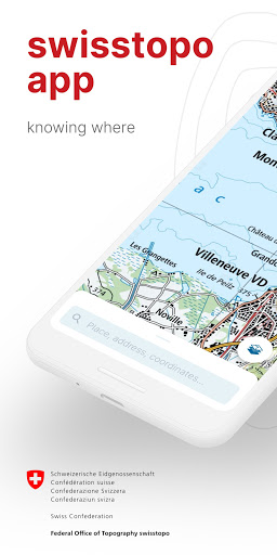
 swisstopo
OS :
Version :VARY
Size :
Updated :Oct 10,2022
Developer :Federal Office of Topography swisstopo
 Ask AI
You can ask
the AI some questions about the app
Based on online discussions about the app "Swisstopo", here are three topics and corresponding questions for you:
**Topic 1: Functionality**
Is the app's map data accurate and easy to navigate?
**Topic 2: Cartographic aspects**
Are the maps sufficiently detailed and inclusive of relevant information?
**Topic 3: User interface**
Does the app's user interface make it easy to find what you're looking for?
 Ask AI
Pros and Cons from users' feedback
Based on the users' reviews of the SwissTopo app, here are three cons and pros in 15 words or less:
**Cons:**
1. Slow loading times and occasional crashes frustrate users.
2. Limited functionality on non-Swiss territories and languages.
3. No clear tutorial or instructions for first-time users.
**Pros:**
1. Accurate and detailed topographic maps of Switzerland.
2. Easy-to-use interface and customizable search functions.
3. Reliable and up-to-date information for outdoor enthusiasts.
App
Downloads
<
>


App
Survey
-
Does the feedback of the application affect the experience?
-
Does the frequency of application notifications affect the experience?
-
What is your Mobile System?
-
Do you think the payment of application features affects the experience?
Description
On the road with the best app of the year: the swisstopo app won the "Master of Swiss Apps 2021" award.
Use the famous national maps to discover even the most remote places in Switzerland and topics such as hiking, cycling, snow sports and aviation. All functions and data of the app as well as offline use are free of charge. The app is free of advertising and does not require a login.
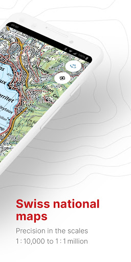
- all scales from 1:10 000 to 1:1 million
- current aerial image and historical maps
- official hiking, mountain hiking and alpine hiking trails
- closures of hiking trails
- snowshoe and ski routes
- SwitzerlandMobility routes
- public transport stops
ON THE ROAD
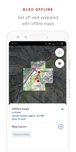
- free offline maps (1:25 000 to 1:1 million)
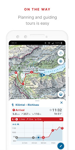
- draw, record, import and share your own tours
- set tour type (hiking, cycling, mountain biking) and personal pace
- tour guide (arrival time, remaining distance)
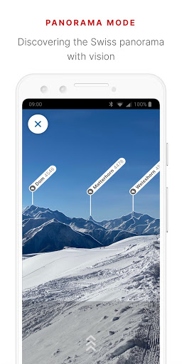
- panorama mode (labelled panorama, view tour in "3D")
- save markers, add notes, share
TOOLS such as measure, compare and search (for geographical names, addresses or coordinates)
Report changes to maps and geodata
AVIATION
- aeronautical charts, obstacles, airspaces
- landing sites
- restrictions for drones and model aircrafts
Do you have a question? Then write to us:
[email protected]
Use the famous national maps to discover even the most remote places in Switzerland and topics such as hiking, cycling, snow sports and aviation. All functions and data of the app as well as offline use are free of charge. The app is free of advertising and does not require a login.
- all scales from 1:10 000 to 1:1 million
- current aerial image and historical maps
- official hiking, mountain hiking and alpine hiking trails
- closures of hiking trails
- snowshoe and ski routes
- SwitzerlandMobility routes
- public transport stops
ON THE ROAD
- free offline maps (1:25 000 to 1:1 million)
- draw, record, import and share your own tours
- set tour type (hiking, cycling, mountain biking) and personal pace
- tour guide (arrival time, remaining distance)
- panorama mode (labelled panorama, view tour in "3D")
- save markers, add notes, share
TOOLS such as measure, compare and search (for geographical names, addresses or coordinates)
Report changes to maps and geodata
AVIATION
- aeronautical charts, obstacles, airspaces
- landing sites
- restrictions for drones and model aircrafts
Do you have a question? Then write to us:
[email protected]
{{descriptionMoreText}}
Comments (4)
{{commentText.length}}/{{maxCommentText}}
{{commentError}}{{commentUserError}}
-
{{comment.commentUser.substring(0, 1)}}By {{comment.commentUser}}{{comment.commentDateString}}
-
QBy Quentin SILVESTREAug 15,2022
-
JBy Jean-Luc PortnerAug 11,2022
-
ABy Amir MohammadiAug 10,2022
-
PBy Paul HicksJul 31,2022
Category Top
apps
- Google Play
- App Store
4
5
Lifestyle
 Daily Diary:Journal with Lock
 Life360: Find Family & Friends
 Pinterest
 T-Mobile Tuesdays
 Frecuencia
Photography
 Picsart AI Photo Editor, Video
 Amazon Photos
 Time Warp Scan - Face Scanner
 ToonApp: Cartoon Photo Editor
 Pixelup - AI Photo Enhancer


More Apps


