


 Art & Design
 Auto & Vehicles
 Beauty
 Business
 Education
 Entertainment
 Finance
 Food & Drink
 Health & Fitness
 House & Home
 Libraries & Demo
 Maps & Navigation
 Medical
 Music & Audio
 Parenting
 Personalization
 Photography
 Productivity
 Shopping
 Social
 Sports
 Tools
Tools Travel & Local
 Video Players
 Weather
 Family


 BackCountry Navigator XE: Topo
OS :
Version :2.5.8
Size :
Updated :Dec 2,2022
Developer :CritterMap Software LLC
 Ask AI
You can ask
the AI some questions about the app
Here are three discussion topics related to the app, turned into questions to ask you:
1. What are your expectations from the GPS navigation feature in Crittermap Backcountry Navigator?
2. How do you plan to use the offline topographic maps and trail guides in the app?
3. What features do you hope to see improved or added in future updates of Crittermap Backcountry Navigator?
 Ask AI
Pros and Cons from users' feedback
Based on the users' reviews of the Backcountry Navigator XE app, here are three cons and pros:
**Cons:**
1. Some users find the app's interface cluttered and overwhelming, with too much information.
2. A few users have reported issues with accuracy, including incorrect trail data and GPS location.
3. Some users feel that the app lacks intuitive navigation and can be frustrating to use.
**Pros:**
1. Most users praise the app's offline capabilities, allowing them to navigate without data or signal.
2. Many users appreciate the detailed topographic maps, elevation profiles, and trail data provided.
3. Users generally find the app's navigation features reliable and easy to use, even in remote areas.
Note that these points are based on a general analysis of user reviews and may not represent every individual experience.
App
Downloads
<
>


App
Survey
-
Do you think the stability of the application affects the experience?
-
What is the number of APPs on your phone?
-
Whether the app response speed affects the experience?
-
Whether the application ad recommendation affects the experience?
Description
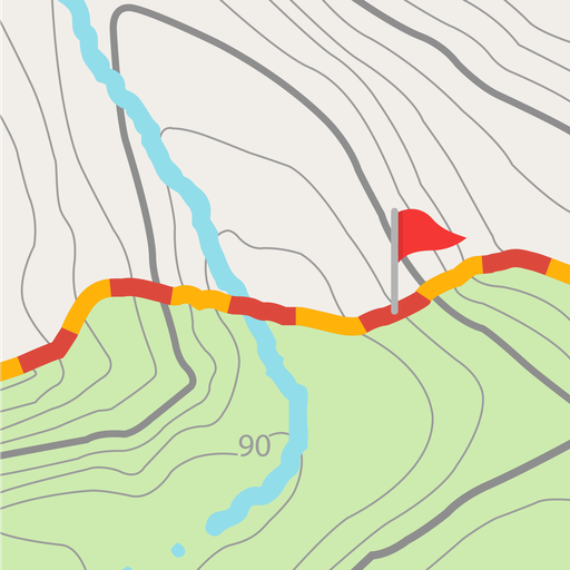
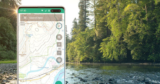
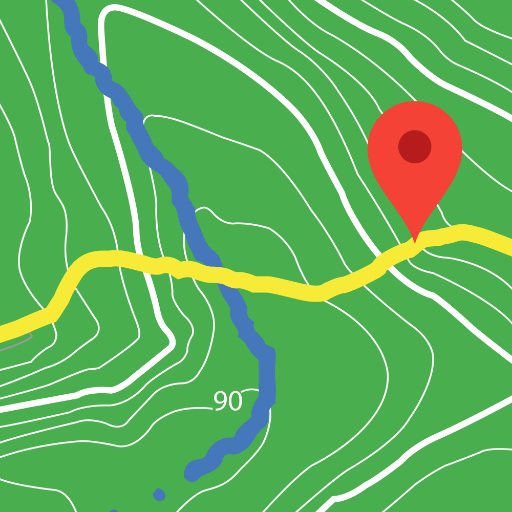
Download and use topo maps offline to explore the outdoors using your smartphone! Use the GPS in your smartphone to navigate, mark your path and record waypoints.
Look at the advantages that BackCountry Navigator XE brings to the table.
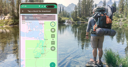
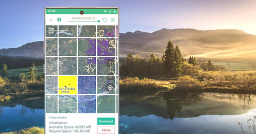
Easy Grid Based Download of Maps
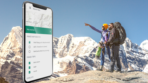
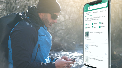
You can try out a simpler approach for downloading and organizing offline maps, choosing large squares at a time. Visualize what you have and what you need.
We have a variety of both worldwide and country specific maps that can be downloaded for offline use based on a yearly membership.
Bronze membership to use most maps.
Silver membership to also use slope shaded topo maps of the US, plus US Forest Service maps.
Gold membership to also use Accuterra Maps, with new, readable maps of the US and the World, plus BackRoads MapBook Basemap in Canada.
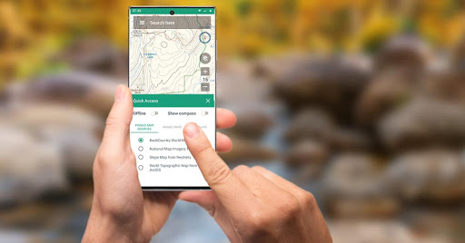
Vector Topo Maps for the World
The default map, BackCountry World map, is a set of Vector topo maps for the world. Vector tiled maps hold the promise of crisp multilevel detail, with the ability to download large chunks of the earth's surface in a quick, compact operation. The BackCountry topo map for the world can be viewed in this app and on bcnavxe.com, with an easy process to install them in large blocks.
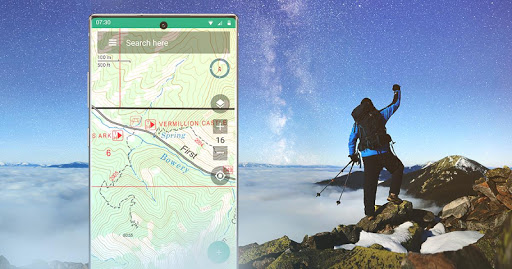
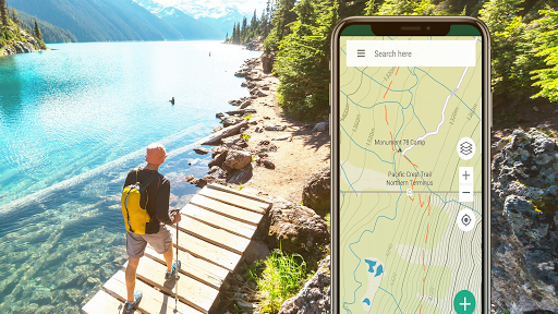
GPS Navigation
Using GPS in a modern day smartphone, see your position on a moving offline map. Find your way to waypoints you mark on the map or create from entering coordinates into the search bar.
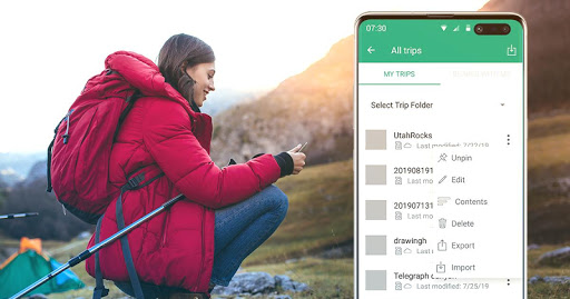
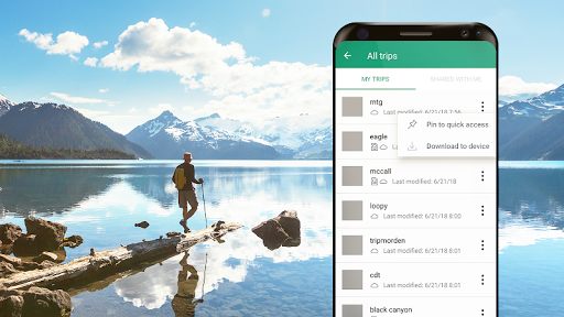
Planning In The Cloud
The website bcnavxe.com is the web interface for BackCountry Navigator XE. With it you can plot points, routes, and boundaries for trips, and download them on demand in the mobile app. You can push trips created in the mobile app to the cloud as well for reviewing or sharing.
Cross-Platform
BackCountry Navigator XE works on Android, has a newer app in iOS, and a web app to aid in planning at bcnavxe.com.
iOS app is available through Appstore
We are well known for our previous product BackCountry Navigator PRO which is still supported and developed on a parallel track.
https://play.google.com/store/apps/details?id=com.crittermap.backcountrynavigator.license
To see why you might want to upgrade to XE from PRO, see this comparison
You can also subscribe to the XE List to get notified of status, updates, and deals.
Look at the advantages that BackCountry Navigator XE brings to the table.
Easy Grid Based Download of Maps
You can try out a simpler approach for downloading and organizing offline maps, choosing large squares at a time. Visualize what you have and what you need.
We have a variety of both worldwide and country specific maps that can be downloaded for offline use based on a yearly membership.
Bronze membership to use most maps.
Silver membership to also use slope shaded topo maps of the US, plus US Forest Service maps.
Gold membership to also use Accuterra Maps, with new, readable maps of the US and the World, plus BackRoads MapBook Basemap in Canada.
Vector Topo Maps for the World
The default map, BackCountry World map, is a set of Vector topo maps for the world. Vector tiled maps hold the promise of crisp multilevel detail, with the ability to download large chunks of the earth's surface in a quick, compact operation. The BackCountry topo map for the world can be viewed in this app and on bcnavxe.com, with an easy process to install them in large blocks.
GPS Navigation
Using GPS in a modern day smartphone, see your position on a moving offline map. Find your way to waypoints you mark on the map or create from entering coordinates into the search bar.
Planning In The Cloud
The website bcnavxe.com is the web interface for BackCountry Navigator XE. With it you can plot points, routes, and boundaries for trips, and download them on demand in the mobile app. You can push trips created in the mobile app to the cloud as well for reviewing or sharing.
Cross-Platform
BackCountry Navigator XE works on Android, has a newer app in iOS, and a web app to aid in planning at bcnavxe.com.
iOS app is available through Appstore
We are well known for our previous product BackCountry Navigator PRO which is still supported and developed on a parallel track.
https://play.google.com/store/apps/details?id=com.crittermap.backcountrynavigator.license
To see why you might want to upgrade to XE from PRO, see this comparison
You can also subscribe to the XE List to get notified of status, updates, and deals.
{{descriptionMoreText}}
Comments (4)
{{commentText.length}}/{{maxCommentText}}
{{commentError}}{{commentUserError}}
-
{{comment.commentUser.substring(0, 1)}}By {{comment.commentUser}}{{comment.commentDateString}}
-
CBy Canadian TracksJul 7,2022
-
FBy Frank McIsaacJun 11,2022
-
ABy Amy GallagherMay 16,2022
-
PBy Pete SApr 27,2022
Developer apps

Category Top
apps
- Google Play
- App Store
4
5
Lifestyle
 Daily Diary:Journal with Lock
 Life360: Find Family & Friends
 Pinterest
 T-Mobile Tuesdays
 Frecuencia
Photography
 Picsart AI Photo Editor, Video
 Amazon Photos
 Time Warp Scan - Face Scanner
 ToonApp: Cartoon Photo Editor
 Pixelup - AI Photo Enhancer


More Apps


