


 Art & Design
 Auto & Vehicles
 Beauty
 Business
 Education
 Entertainment
 Finance
 Food & Drink
 Health & Fitness
 House & Home
 Libraries & Demo
 Maps & Navigation
 Medical
 Music & Audio
 Parenting
 Personalization
 Photography
 Productivity
 Shopping
 Social
 Sports
 Tools
Tools Travel & Local
 Video Players
 Weather
 Family


 Garmin StreetCross
OS :
Version :1.61
Size :
Updated :Nov 23,2022
Developer :Garmin
 Ask AI
 Ask AI
Pros and Cons from users' feedback
Based on the reviews of the StreetCross app on Google Play, here are three cons and pros in English, with each item limited to 15 words:
**Cons:**
1. "Crashes frequently, causing me to lose my ride and wasting my time." (9 words)
2. "Navigation is poor, often leading me to take wrong turns and get lost." (11 words)
3. "Lacks comprehensive mapping, making it difficult to explore new areas." (12 words)
**Pros:**
1. "Easy to use, even for those who are new to GPS routing." (10 words)
2. "Provides accurate distance, speed, and estimated time of arrival information." (12 words)
3. "Helped me discover new cycling routes and trails in my area." (11 words)
App
Downloads
<
>


App
Survey
-
Do you think the aesthetics of the interface UI affects the experience?
-
How much traffic the app consumes Does it affect the experience?
-
Does the feedback of the application affect the experience?
-
What is your Mobile System?
Description
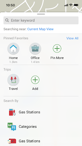
Garmin StreetCross is a motorcycle navigation app specifically designed for the Yamaha XMAX 2023 model. This app will only work in combination with this specific motorcycle.
The navigation operations can be done via motorcycle handlebar during the ride.
Download maps into your smartphone, enjoy best-ever riding NOW!
Key Features
Garmin Real Directions
Get spoken turn-by-turn directions through your connected helmet or headset.
Meanwhile, navigation features are projected to motorcycle meter panel when smartphone is connected to motorcycle via Bluetooth®.
Live Traffic
Avoid traffic delays and find timesaving detours to help keep you on your way with live traffic updates.
PhotoReal Junction View
It displays the appropriate lane to drive in during an active route.
Junction view realistically depicts junctions and interchanges along your route, including road signs and the surrounding landscape;
A brightly colored arrow indicates the lane needed for your next turn or exit.
Rider Alerts
Get alerts for hazards along your route, such as upcoming sharp curves.
You’ll also be notified about speed limit, speed camera, or school nearby along the route.
Live Weather
Show weather, temperature along the ride.
Share the Ride
Share tracks with fellow riders by sending GPX files.
*Some navigation features are not available in all regions.
Note: Continued use of GPS running in the background can dramatically decrease battery life.
Privacy Policy: https://www.garmin.com/privacy/consumerauto/policy/
{{descriptionMoreText}}
Comments (0)
{{commentText.length}}/{{maxCommentText}}
{{commentError}}{{commentUserError}}
-
{{comment.commentUser.substring(0, 1)}}By {{comment.commentUser}}{{comment.commentDateString}}
Developer apps
- Google Play
- App Store
 Garmin Drive™
 Garmin Connect™
 dēzl™
dēzl™ Garmin Explore™
 Garmin RV Controls
 Garmin Messenger™
 Garmin Mechanic™
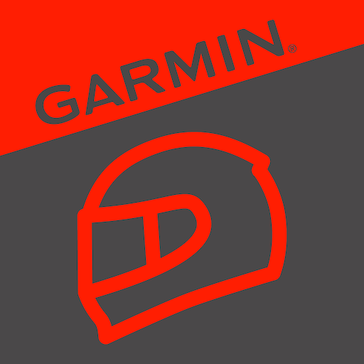 Garmin Catalyst™
 Garmin PowerSwitch™
 CANINE
 Garmin eLog™ Compliant ELD
 Garmin Impact™ / Garmin Impact
 Garmin STRIKER™ Cast
 Tread™
 Garmin Clipboard™
 Garmin ActiveCaptain®
 Garmin Golf
 Garmin Dive™
 Garmin Xero® S
 Garmin Smartphone Link
 Garmin Jr.™
 Connect IQ™ Store
 Garmin VIRB
 Tacx Training
 Garmin Varia™
 Garmin Connect™
 Garmin Explore™
 Garmin Drive™
 Garmin PowerSwitch™
 Garmin Catalyst™
 Garmin Impact™ / Garmin Impact
 Garmin Xero® S
 Tread™
 Garmin Clipboard™
 Garmin VIRB Edit
 Garmin STRIKER™ Cast
 Garmin Canine
 POI Loader
 Garmin Varia™
 Garmin eLog
 Garmin Dive™
 Tacx Training
 Garmin WebUpdater
 dēzl™
dēzl™ Garmin VIRB
 Garmin BaseCamp
 Fusion-Link
 Garmin Golf
 Garmin Jr.™
 Garmin Smartphone Link
 Connect IQ™ Store
 Garmin ActiveCaptain®
Category Top
apps
- Google Play
- App Store
4
5
Lifestyle
 Daily Diary:Journal with Lock
 Life360: Find Family & Friends
 Pinterest
 T-Mobile Tuesdays
 Frecuencia
Photography
 Picsart AI Photo Editor, Video
 Amazon Photos
 Time Warp Scan - Face Scanner
 ToonApp: Cartoon Photo Editor
 Pixelup - AI Photo Enhancer


More Apps


