


 Art & Design
 Auto & Vehicles
 Beauty
 Business
 Education
 Entertainment
 Finance
 Food & Drink
 Health & Fitness
 House & Home
 Libraries & Demo
 Maps & Navigation
 Medical
 Music & Audio
 Parenting
 Personalization
 Photography
 Productivity
 Shopping
 Social
 Sports
 Tools
Tools Travel & Local
 Video Players
 Weather
 Family


 Altimeter (offline true altitu
OS :
Version :3.3.5
Size :
Updated :Jul 3,2022
Developer :PixelProse SARL
 Ask AI
 Ask AI
Pros and Cons from users' feedback
Based on the user reviews, here are three cons and three pros, 15 words limited for each item:
**Cons:**
1. Discontinuous tracking: Users mention that the app sometimes stops tracking altitude data without warning.
2. Limited compatibility: Some users experience issues with the app on older devices or those with less memory.
3. Lack of alerts: Reviewers suggest adding customizable alerts for unusual altitude changes or specific milestones.
**Pros:**
1. Accurate data: Users praise the app's accuracy in tracking altitude, even in extreme conditions.
2. Customizable UI: Reviewers appreciate the app's flexible layout options for a tailored user experience.
3. Simple and intuitive: Most users find the app easy to use, with a minimalistic design that doesn't overwhelm.
App
Downloads
<
>

App
Survey
-
Why do you uninstall an app?
-
Does the feedback of the application affect the experience?
-
What is your Mobile System?
-
Do you often use the tools app that comes with your phone
Description
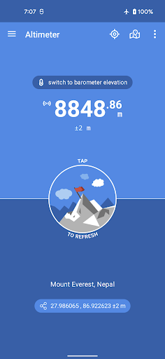
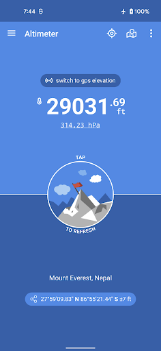
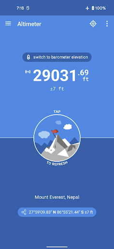
Altimeter is an handy Android application allowing you to get true altitude above sea level (MSL) at your current location or any location on earth. It requires access to your device location to get raw altitude from the GPS signal. True altitude above mean sea level is determined using EGM96 Earth Gravitational Model. Main features are :
• No network required (works offline and in flight mode)
• True altitude above sea level (AMSL using EGM96)
• Use Barometer or GPS Satellite
• Address at current location
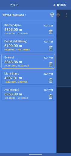
• Save altitude at location
• Altitude accuracy estimation
• Horizontal accuracy estimation
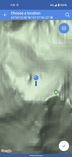
• Altitude at any location
• Pick location on a Map
• Open photo geotags to display associated altitude
• Search for a location by name or address
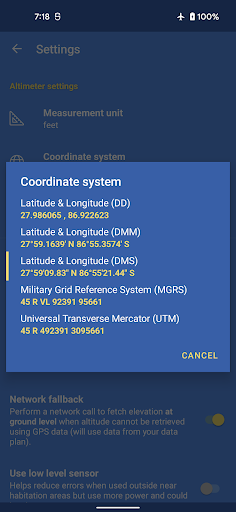
• Universal Transverse Mercator coordinates (UTM)
• Military Grid Reference System coordinates (MGRS)
• Home screen widget to display altitude at current position
Network access is required to get the altitude of a location picked from the map.
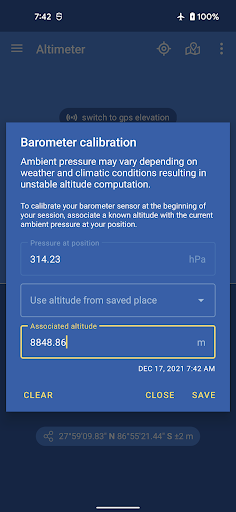
Height above mean sea level (AMSL) is the elevation (on the ground) or altitude (in the air) of an object, relative to the average sea level datum. Normal GPS elevation considers the entire Earth as an ellispoid and differences up to 100 metres (328 feet) can exist between this ellipsoid height and true mean tidal height. The alternative, which is what we use in Altimeter PRO, is a geoid-based vertical datum such as the global EGM96 model.
Altitude vertical accuracy is defined at 68% confidence. Specifically, as 1-side of the 2-sided range above and below the estimated altitude reported, within which there is a 68% probability of finding the true altitude.
Enjoy!
• No network required (works offline and in flight mode)
• True altitude above sea level (AMSL using EGM96)
• Use Barometer or GPS Satellite
• Address at current location
• Save altitude at location
• Altitude accuracy estimation
• Horizontal accuracy estimation
• Altitude at any location
• Pick location on a Map
• Open photo geotags to display associated altitude
• Search for a location by name or address
• Universal Transverse Mercator coordinates (UTM)
• Military Grid Reference System coordinates (MGRS)
• Home screen widget to display altitude at current position
Network access is required to get the altitude of a location picked from the map.
Height above mean sea level (AMSL) is the elevation (on the ground) or altitude (in the air) of an object, relative to the average sea level datum. Normal GPS elevation considers the entire Earth as an ellispoid and differences up to 100 metres (328 feet) can exist between this ellipsoid height and true mean tidal height. The alternative, which is what we use in Altimeter PRO, is a geoid-based vertical datum such as the global EGM96 model.
Altitude vertical accuracy is defined at 68% confidence. Specifically, as 1-side of the 2-sided range above and below the estimated altitude reported, within which there is a 68% probability of finding the true altitude.
Enjoy!
{{descriptionMoreText}}
Comments (4)
{{commentText.length}}/{{maxCommentText}}
{{commentError}}{{commentUserError}}
-
{{comment.commentUser.substring(0, 1)}}By {{comment.commentUser}}{{comment.commentDateString}}
-
MBy Max TensorerAug 19,2022
-
MBy Michel NoëlAug 19,2022
-
PBy Patrick CIBOISAug 18,2022
-
MBy Matthieu WiartAug 16,2022


Category Top
apps
- Google Play
- App Store
4
5
Lifestyle
 Daily Diary:Journal with Lock
 Life360: Find Family & Friends
 Pinterest
 T-Mobile Tuesdays
 Frecuencia
Photography
 Picsart AI Photo Editor, Video
 Amazon Photos
 Time Warp Scan - Face Scanner
 ToonApp: Cartoon Photo Editor
 Pixelup - AI Photo Enhancer


More Apps


