


 Art & Design
 Auto & Vehicles
 Beauty
 Business
 Education
 Entertainment
 Finance
 Food & Drink
 Health & Fitness
 House & Home
 Libraries & Demo
 Lifestyle
 Maps & Navigation
 Medical
 Music & Audio
 Parenting
 Personalization
 Photography
 Productivity
 Shopping
 Social
 Sports
 Tools
Tools Travel & Local
 Video Players
 Weather
 Family


 Weather4D Routing & Navigation
OS :
Version :2.0.81
Size :604.53Mb
Updated :Aug 2,2022
Developer :APP4NAV
 Ask AI
You can ask
the AI some questions about the app
Here are three topics related to the Weather4D app that users often discuss online:
1. Navigation accuracy: Is the app's routing navigation feature effective in different weather conditions, such as heavy rain or fog?
2. Offline map usage: Can users access the app's maps and navigation offline, and if so, are there any limitations or issues?
3. Weather forecast reliability: How accurate are the weather forecasts provided by the app, and are they trustworthy for making decisions about daily activities?
 Ask AI
Pros and Cons from users' feedback
Based on the user reviews, here are three pros and three cons of the Weather4D - Routing & Navigation app:
**Pros:**
1. **Accurate Weather Forecast**: Users praise the app for its accurate weather forecasts, helping them plan their routes effectively.
2. **Easy to Use Interface**: Reviewers find the app's interface user-friendly and intuitive, making it easy to navigate and access features.
3. **Detailed Information**: Users appreciate the app's provision of detailed weather and road condition information, which helps them make informed decisions.
**Cons:**
1. **Glitches and Crashes**: Some users experience glitches and crashes, which can be frustrating and disrupt their routing experience.
2. **Poor User Support**: Reviewers express disappointment with the app's customer support, citing slow responses and unhelpful assistance.
3. **Limited Off-Grid Functionality**: Users find that the app's functionality is limited when no cellular signal is available, which can be a drawback for those who venture off-grid regularly.
Let me know if you'd like me to expand on these findings!
App
Downloads
<
>
App
Survey
-
What is the number of APPs on your phone?
-
Where do you get the new APP
-
Application technology innovation Does it affect the experience?
-
Does the update frequency of the application affect the experience?
Description
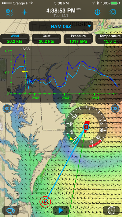
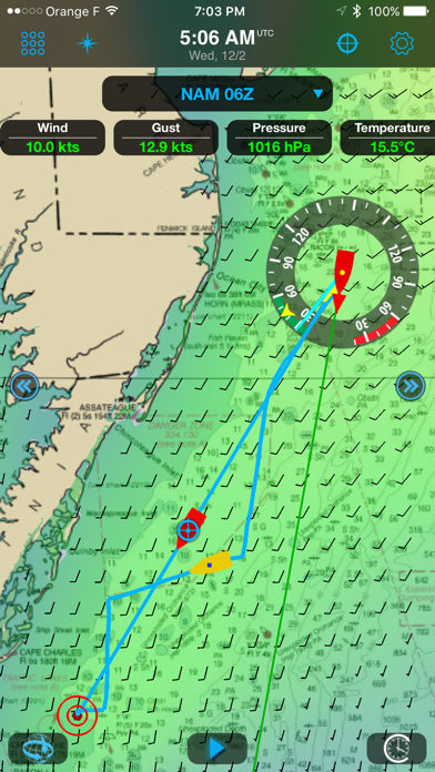
Weather4D Routing & Navigation integrates weather forecasting, routing calculations, navigation with digitized raster charts, instruments and data sharing to maximize your boating experience.
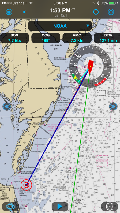
Navigation
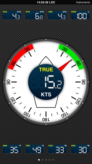
See SOG, COG, VMC, HDG, TWS, AWS, ETAs, ETWs, AIS data and more in real time along with weather and routing information with a wifi connection to a transponder.
Store your charts on your device for offshore/offline navigations.
Set the screen to night mode after sunset to better see what’s happening outside during your watch.
Set alarms to alert about excessive XTE, course deviations, surrounding boats, excessive wind speed and low depth.
Take advantage of the iPad/iPhone built in compass, pressure and acceleration sensors.
Connect bluetooth devices like wireless anemometers and wind vanes.
Share AIS and boat sensors data like wind, current, pressure, air and sea temperature within the Weather4D users community.
Activate Man Overboard safety feature to estimate drift and thus rescue location based on current and wind.
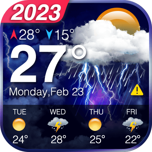
Weather
View combined weather data displayed in 3D HD layers animated automatically or manually by sliding a finger on the screen.
Use GFS model to get started. In addition, over 35 weather and oceanographic models are available with a yearly subscription (in-app purchase).
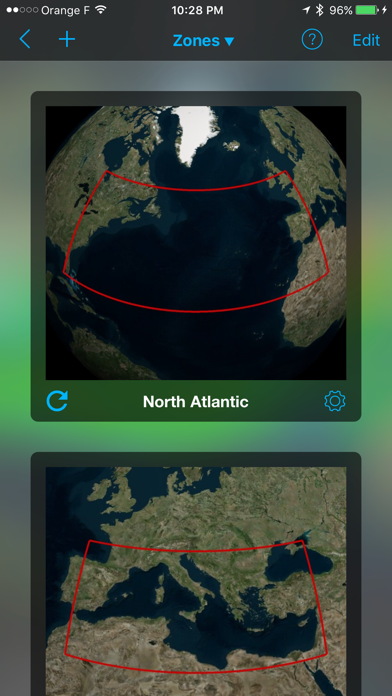
Create your own geographical zones, select the models you need and download only the characteristics that matter to you: data type, resolution, periodicity, file size, etc. GRIB files can be downloaded anywhere through a regular or satellite internet connection.
Split the screen (iPad only) to combine and/or compare: navigation and weather, weather and waves or currents, two weather models…
Routing
Routing calculation optimizes for safety, comfort and performance when sailing, motoring, or mixing the two.
Create a route and calculate its associated routings in function of departure dates/times, forecasts (weather, wave and current), minimum sailing speed, motoring speed, boat polar, maximum wind and minimum distance to the coast.
Visualize sail configurations based on your routings and your own set of sails.
Save waypoints, locations, simulate routes, combine them with GRIB forecast models.
Restart a routing calculation at anytime from the actual boat position.
Default Models and Charts
————————————
GFS global forecast model at 0.25 °, 0.5 °, 1 ° and 2 ° resolutions
BING global chart
OSM (Opens Street Map) global chart
Optional Models (GRIBs) and Nautical Charts (additional fees apply)
——————————————————————————————-
ECMWF
NAM USA
GEM Global
COAMPS Europe, West Atlantic, Central America, East Pacific
ICON-EU Europe
ARPEGE Global, Europe
AROME France, Antilles, Guyane, Polynésie, Calédonie, Indien
AROME HD France
WRF France, Europe, Greece, NW Africa, Azores, Lesser Antilles
Greater Antilles
Waves:
MFWAM Global, Europe, France
FNMOC WW3 Global, Europe
Currents:
MyOcean Global, IBI, NWS, Baltic, Med
NCOM AMSEAS, USEAST, ALASKA, SOCAL, HAWAII
Nautical Charts:
GeoGarage is Weather4D supplier and offers by subscription access to more than 10,000 nautical charts derived from International Hydrographic Services. Pricing and chart selection is set per publisher. Updates are released regularly under chart publishers authority. Once the subscription is purchased, charts are instantly accessible within the application.
Available publishers:
NOAA RNCs (USA)
CHS (Canada)
WAVEYLINE (Bahamas)
DHNV (Venezuela)
DHN (Brazil)
SHN (Argentina)
LINZ (New Zealand)
SHOM (France / DOM-TOM / Polynesia + international)
UKHO (UK and dependencies + international)
BSH (Germany)
NLHO (Netherlands)
VLAAMSE (Belgium)
DGA (Denmark)
NHS (Norway)
ICG-HD (Iceland)
NAVIMAP / IIM (Italy)
ENC_ES (Spain)
ENC_HR (Croatia)
BLP (West Mexico)
IMRAY (North Sea, English Channel, West Britain & Ireland, Atlantic France, Iberia & Atlantic Islands, Western Mediterranean, Central Mediterranean, East Mediterranean, Netherlands)
GeoCuba (Cuba)
{{descriptionMoreText}}
Comments (0)
{{commentText.length}}/{{maxCommentText}}
{{commentError}}{{commentUserError}}
-
{{comment.commentUser.substring(0, 1)}}By {{comment.commentUser}}{{comment.commentDateString}}
Developer apps

Category Top
apps
- Google Play
- App Store


More Apps


