


 Art & Design
 Auto & Vehicles
 Beauty
 Business
 Education
 Entertainment
 Finance
 Food & Drink
 Health & Fitness
 House & Home
 Libraries & Demo
 Maps & Navigation
 Medical
 Music & Audio
 Parenting
 Personalization
 Photography
 Productivity
 Shopping
 Social
 Sports
 Tools
Tools Travel & Local
 Video Players
 Weather
 Family


 Trimble Unity
OS :
Version :5.4.4
Size :
Updated :Jul 15,2022
Developer :Trimble Inc.
 Ask AI
You can ask
the AI some questions about the app
Here are three topics that users may discuss about the Trimble Unity app, turned into questions:
1. How does the app's accuracy feature, "Unity", help in precision mapping and navigation?
2. Can the app integrate with other Trimble devices and software for a seamless workflow?
3. Are there any limitations or restrictions on using the app's advanced 3D modeling and visual processing features?
 Ask AI
Pros and Cons from users' feedback
Based on the users' reviews, here are three cons and pros of the app:
**Cons:**
1. "Crashes frequently, especially when changing modes, requires constant restarting."
2. "Lack of clear instructions, leading to confusion and frustration for new users."
3. "No option to customize settings or adjust sensitivities to individual needs."
**Pros:**
1. "Accurate navigation and tracking, even in areas with limited GPS signal."
2. "User-friendly interface, easy to navigate and access key features."
3. "Regular updates with new features and improvements, shows developer's commitment."
App
Downloads
<
>


App
Survey
-
The degree of memory and power consumption Does it affect the experience?
-
What is your Mobile System?
-
Do you think the stability of the application affects the experience?
-
Why do you uninstall an app?
Description
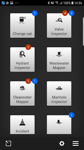
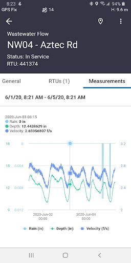
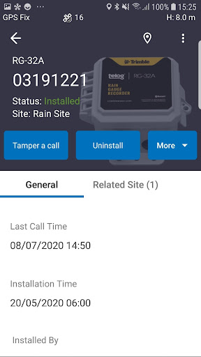
Trimble® Unity Work Management and Remote Monitoring softwares offer a unified cloud-based, GIS-centric and mobile collaboration suite of applications for water, wastewater and stormwater asset and network management. Includes advanced workflows to map, manage, measure and improve asset performance, reduce operations costs, and improve public health and safety
Combined with Trimble’s GNSS, Telog IoT recorders and sensors, and Esri’s GIS technologies, the software offers advanced features to map, locate and assess the performance of critical infrastructure assets, enabling utilities to keep their field infrastructure data up-to-date and accurate, monitor asset operating conditions, manage leak repairs, reduce non-revenue water, deploy and inspect smart meters, lower potential threats to safety and health due to contamination and adhere to regulators’ reporting guidelines and requirements.
• GIS-centric solution, enabling water utility personnel to bring GIS and asset information out to the field
• Eliminates error prone paper and manual data entry
• Operates online and offline with full access to asset data
• Provides seamless flow of data between the field and office
• Provides intelligent data collection forms and workflows using business rules, default values and conditional attributes
• Captures photos and Accurate GPS positions
• Deploy and manage Telog IoT recorders and sensors
• View IoT asset performance data in the field during event response.
{{descriptionMoreText}}
Comments (1)
{{commentText.length}}/{{maxCommentText}}
{{commentError}}{{commentUserError}}
-
{{comment.commentUser.substring(0, 1)}}By {{comment.commentUser}}{{comment.commentDateString}}
-
ABy A Google userApr 4,2017
Developer apps
- Google Play
- App Store


Category Top
apps
- Google Play
- App Store
4
5
Lifestyle
 Daily Diary:Journal with Lock
 Life360: Find Family & Friends
 Pinterest
 T-Mobile Tuesdays
 Frecuencia
Photography
 Picsart AI Photo Editor, Video
 Amazon Photos
 Time Warp Scan - Face Scanner
 ToonApp: Cartoon Photo Editor
 Pixelup - AI Photo Enhancer


More Apps


