


 Art & Design
 Auto & Vehicles
 Beauty
 Business
 Education
 Entertainment
 Finance
 Food & Drink
 Health & Fitness
 House & Home
 Libraries & Demo
 Lifestyle
 Maps & Navigation
 Medical
 Music & Audio
 Parenting
 Personalization
 Photography
 Productivity
 Shopping
 Social
 Sports
 Tools
Tools Travel & Local
 Video Players
 Weather
 Family


 RadarScope 4
OS :
Version :4.7.2
Size :32.33Mb
Updated :Jun 23,2022
Developer :Base Velocity, LLC
 Ask AI
You can ask
the AI some questions about the app
Here are three topics that users of Radarscope 4 might discuss on the Internet, in the form of questions:
1. How do you think Radarscope 4's satellite imaging capabilities will help you track severe weather events?
2. Can you recommend any specific settings or preferences that enhance RadarScope 4's display for storm chasing or research purposes?
3. Are you satisfied with Radarscope 4's real-time data update frequency and coverage across different regions?
 Ask AI
Pros and Cons from users' feedback
Based on the users' reviews of the RadarScope app, here are three cons and pros:
**Cons:**
1. "Occasional lag and freezing issues, frustrating when trying to quickly check radar images."
2. "Somewhat difficult to discern between different types of weather symbols and alerts."
3. "No support for custom notifications, would be nice to have specific alert options."
**Pros:**
1. "Extremely accurate and reliable radar data, essential for severe weather tracking."
2. "Clean and intuitive design, easy to navigate and understand."
3. "Very useful feature to display multiple radar angles at once, fantastic for storm chasers."
App
Downloads
<
>
App
Survey
-
What is the number of APPs on your phone?
-
The degree of memory and power consumption Does it affect the experience?
-
Do you think the tools app that comes with your phone is useful?
-
Do you often use the tools app that comes with your phone
Description
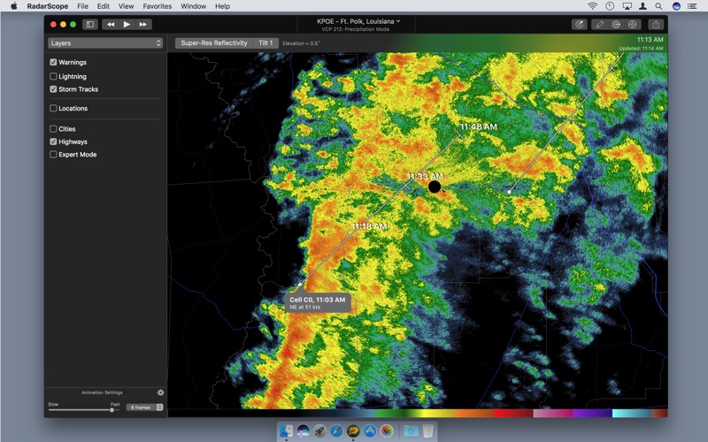
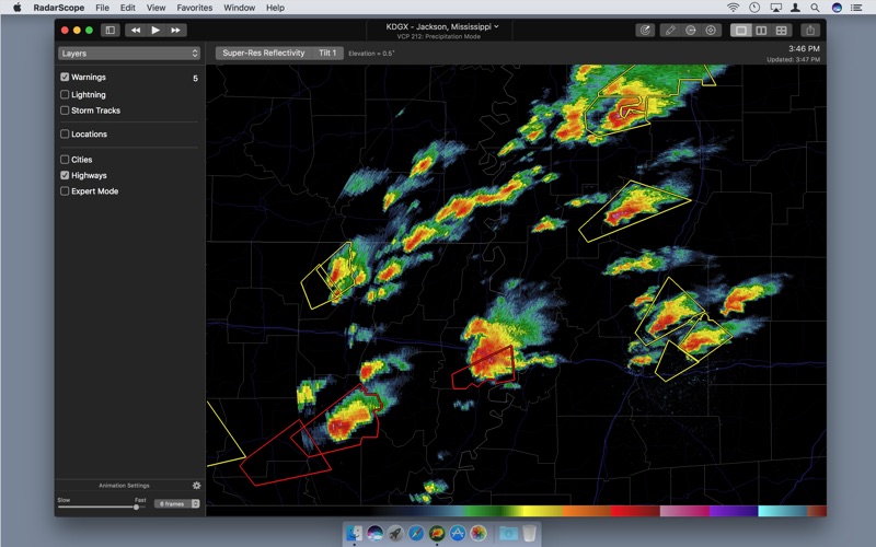
RadarScope is a specialized display utility for weather enthusiasts and meteorologists that allows you view NEXRAD Level 3 and super-resolution radar data along with tornado, severe thunderstorm, flash flood, special marine and snow squall warnings, and predicted storm tracks issued by the U.S. National Weather Service. It can display the latest reflectivity, velocity, dual-polarization, and other products from any NEXRAD or TDWR radar site in the United States, Guam, Puerto Rico, Korea, and Okinawa, as well as data from Environment Canada, Australian Bureau of Meteorology, Finnish Meteorological Institute, and German Weather Service radars. These aren't smoothed PNG or GIF images, this is native radar data rendered in its original radial format for a high level of detail.
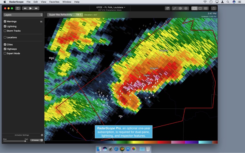
Whether you are scanning reflectivity for a mesocyclone's tell-tale hook echo, trying to pinpoint the landfall of a hurricane's eye wall, or looking for small features like velocity couplets in the storm relative radial velocity product, RadarScope gives you the power to view true radial weather radar data.
RadarScope displays tornado, severe thunderstorm, flash flood, special marine, and snow squall warnings issued by the U.S. National Weather Service. You can browse the list of active warnings in the information sidebar, select a warning to view the details, and even zoom to the selected warning on the map.
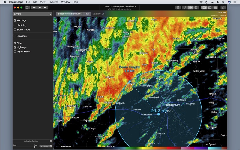
Zoom in and out on the map using the mouse or pinch gestures on multi-touch trackpads. Click and drag to scroll around the map. Select one of the 307 different radars in the United States, Canada, Australia, Germany, Korea, Puerto Rico, Guam, or Okinawa. Tap the play button to download and animate over recent images. Display the names of over 25,000 cities and towns on the map as you zoom and scroll. Move the cursor over the color legend to see the data value associated with each color. You can also export the currently displayed map to several common image formats.
Meanwhile, RadarScope will retrieve and display updated data automatically and intelligently (approximately every 2 to 10 minutes, depending on the radar scan strategy).
You can display radar data from our servers, NOAA's public access web site, or your Allison House subscriber account.
RadarScope Pro is an optional auto-renewing subscription with two different tiers to choose from.
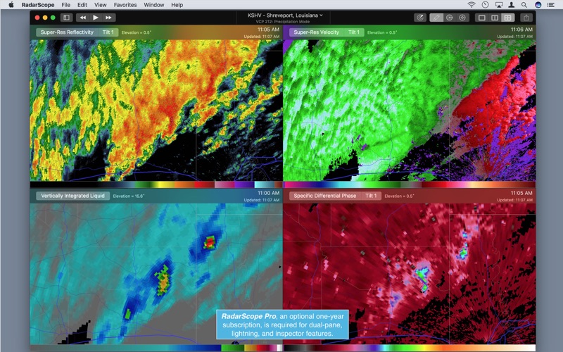
RadarScope Pro Tier One is an annual subscription that provides access to real-time lightning data in the U.S. and Canada that animates along with the radar loop and up to 30 frames of radar data, including extended loops of super-resolution data. Tier One subscribers can also access optional dual-pane and quad-pane modes for viewing multiple radar products side-by-side.
RadarScope Pro Tier Two is an annual or monthly subscription that combines all the features in Tier One with more advanced features, including SPC outlooks, mesoscale discussions, local storm reports, hail size and probability contours, and azimuthal shear contours in the U.S., a 30-day archive of all radar products, and the ability to use subscription features across multiple platforms.
If you choose to buy the RadarScope Pro subscription, it will charged to your iTunes account. The subscription will be auto-renewed within 24 hours prior to the end of the current period at the same price you originally paid. Subscriptions may be managed and auto-renewal disabled via your iTunes Account Settings after the purchase. Once purchased, the subscription cannot be cancelled during the active subscription period.
DTN is committed to safeguarding your privacy online. Our privacy policy is available for review at: https://www.dtn.com/privacy-policy/
Please visit our web site for more information.
{{descriptionMoreText}}
Comments (3)
{{commentText.length}}/{{maxCommentText}}
{{commentError}}{{commentUserError}}
-
{{comment.commentUser.substring(0, 1)}}By {{comment.commentUser}}{{comment.commentDateString}}
-
ZBy ZoneXeroJun 9,2020
-
GBy G4geneJul 18,2019
-
gBy gtdandyJun 5,2021
Developer apps
Category Top
apps
- Google Play
- App Store


More Apps


