


 Art & Design
 Auto & Vehicles
 Beauty
 Business
 Education
 Entertainment
 Finance
 Food & Drink
 Health & Fitness
 House & Home
 Libraries & Demo
 Maps & Navigation
 Medical
 Music & Audio
 Parenting
 Personalization
 Photography
 Productivity
 Shopping
 Social
 Sports
 Tools
Tools Travel & Local
 Video Players
 Weather
 Family


 PeakVisor - 3D Maps & Peaks Id
OS :
Version :2.8.25
Size :
Updated :Oct 31,2022
Developer :Routes Software SRL
 Ask AI
You can ask
the AI some questions about the app
Based on the app, here are three topics that users might discuss on the internet:
1. How accurate is the PeakVisor app in predicting sunrise and sunset times?
2. What are the best features of PeakVisor for outdoor enthusiasts and nature lovers?
3. Does PeakVisor provide enough detailed information about trail maps and route planning?
Let me know if you need anything else!
 Ask AI
Pros and Cons from users' feedback
Based on the user reviews, here are three cons and three pros, 15 words limited for each item:
**Cons:**
1. Insufficient detailed maps and road data in some areas, leading to navigation issues.
2. Occasionally, the app crashes or freezes, causing frustration and lost directions.
3. Limited filtering options for points of interest and waypoints, making search tedious.
**Pros:**
1. The app's peak-visor feature provides accurate and real-time mountain weather forecasts, a lifesaver.
2. User-friendly interface and easy-to-use navigation make exploring new trails a breeze.
3. Reliable offline functionality allows for adventure without dependence on internet connectivity.
App
Downloads
<
>

App
Survey
-
Does the frequency of application notifications affect the experience?
-
Ease of use of the application Does it affect the experience?
-
How much time do you spend on app applications every day?
-
Do you think the aesthetics of the interface UI affects the experience?
Description
PeakVisor will make you a superhero of outdoors navigation by putting state-of-the-art 3D maps and mountain identification in the palm of your hand.
"PeakVisor is a seemingly magical app that instantly recognizes the name of any mountain peak that comes into view using a combination of your phone’s camera" - Atlas & Boots
"A lovely little app that uses your phone’s camera and the power of augmented reality to identify any mountain you aim the camera at." - Digital Trends
Key Features:
● Mountains Identification
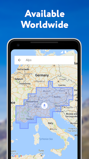
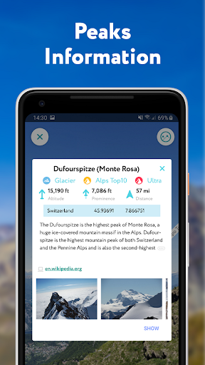
Identify more than a million hills & mountains all over the world and get a detailed profile for each one of them, including altitude, topographic prominence, mountain range, what national parks or reserves it may belong to, as well as photos and Wikipedia articles. It is one of the most useful Augmented Reality technology applications on the market today.
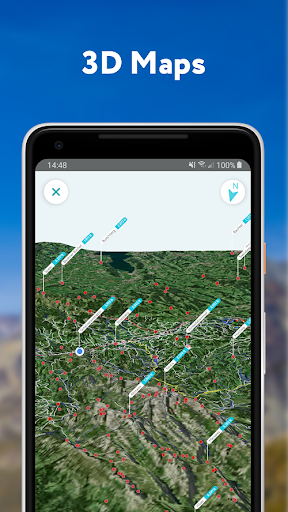
● 3D Maps
Get your topo maps of the future. Cutting edge technology with high-precision terrain modeling allows simple, yet effective insight into the landscape of the mountains. It is the most convenient way to explore a mountainous area, its trails, summits, passes, viewpoints, and even parking areas.
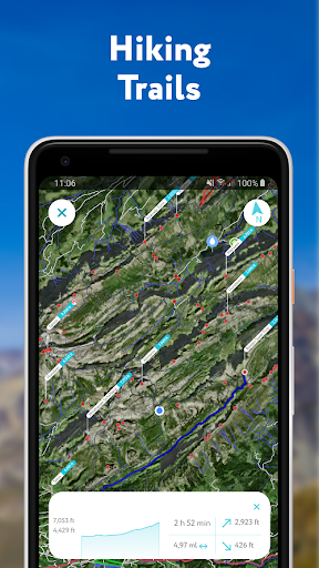
● Hiking Route Planner
A vast network of worldwide hiking trails and walking pathways included in PeakVisor’s 3D Maps will help you compose a hiking route, which includes, evaluating the distance you can expect to hike, as well as a route’s elevation profile, and estimated time for completion. To help you plan your route we’ve included points of interest in our 3D Maps such as mountain huts, parking lots, cable cars, viewpoints, castles, etc.
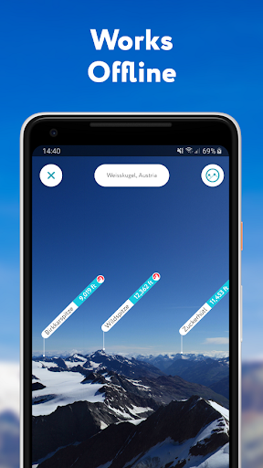
● Everything works Offline
Internet connection is not a prerequisite for the PeakVisor app. All the data is downloadable and ready for use no matter where you are or what altitude you might be at.
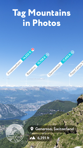
● Identifying Mountains in Photos
If you have photos from previous hikes that you did not take through the app, you can still find out what peaks you saw by download your images into the PeakVisor app and adding a digital overlay of the mountains with names and altitudes of all the peaks in view.
● Photo Planning
PeakVisor’s Sun and Moon trajectories come super handy when planning the perfect time to take pictures.
PeakVisor is the Swiss army knife of outdoor adventure and will soon be indispensable to you future hiking needs. Just keep it in your backpack and you'll get value from it every time you’re on the trail!
If you have any questions or just feel like talking about mountains, please contact us at [email protected]
"PeakVisor is a seemingly magical app that instantly recognizes the name of any mountain peak that comes into view using a combination of your phone’s camera" - Atlas & Boots
"A lovely little app that uses your phone’s camera and the power of augmented reality to identify any mountain you aim the camera at." - Digital Trends
Key Features:
● Mountains Identification
Identify more than a million hills & mountains all over the world and get a detailed profile for each one of them, including altitude, topographic prominence, mountain range, what national parks or reserves it may belong to, as well as photos and Wikipedia articles. It is one of the most useful Augmented Reality technology applications on the market today.
● 3D Maps
Get your topo maps of the future. Cutting edge technology with high-precision terrain modeling allows simple, yet effective insight into the landscape of the mountains. It is the most convenient way to explore a mountainous area, its trails, summits, passes, viewpoints, and even parking areas.
● Hiking Route Planner
A vast network of worldwide hiking trails and walking pathways included in PeakVisor’s 3D Maps will help you compose a hiking route, which includes, evaluating the distance you can expect to hike, as well as a route’s elevation profile, and estimated time for completion. To help you plan your route we’ve included points of interest in our 3D Maps such as mountain huts, parking lots, cable cars, viewpoints, castles, etc.
● Everything works Offline
Internet connection is not a prerequisite for the PeakVisor app. All the data is downloadable and ready for use no matter where you are or what altitude you might be at.
● Identifying Mountains in Photos
If you have photos from previous hikes that you did not take through the app, you can still find out what peaks you saw by download your images into the PeakVisor app and adding a digital overlay of the mountains with names and altitudes of all the peaks in view.
● Photo Planning
PeakVisor’s Sun and Moon trajectories come super handy when planning the perfect time to take pictures.
PeakVisor is the Swiss army knife of outdoor adventure and will soon be indispensable to you future hiking needs. Just keep it in your backpack and you'll get value from it every time you’re on the trail!
If you have any questions or just feel like talking about mountains, please contact us at [email protected]
{{descriptionMoreText}}
Comments (4)
{{commentText.length}}/{{maxCommentText}}
{{commentError}}{{commentUserError}}
-
{{comment.commentUser.substring(0, 1)}}By {{comment.commentUser}}{{comment.commentDateString}}
-
dBy dave de kroonAug 15,2022
-
DBy David WillertonAug 14,2022
-
ABy Alexis ColeJun 7,2022
-
OBy Oleksii HorishniiMay 12,2022


Category Top
apps
- Google Play
- App Store
4
5
Lifestyle
 Daily Diary:Journal with Lock
 Life360: Find Family & Friends
 Pinterest
 T-Mobile Tuesdays
 Frecuencia
Photography
 Picsart AI Photo Editor, Video
 Amazon Photos
 Time Warp Scan - Face Scanner
 ToonApp: Cartoon Photo Editor
 Pixelup - AI Photo Enhancer


More Apps


