


 Art & Design
 Auto & Vehicles
 Beauty
 Business
 Education
 Entertainment
 Finance
 Food & Drink
 Health & Fitness
 House & Home
 Libraries & Demo
 Lifestyle
 Maps & Navigation
 Medical
 Music & Audio
 Parenting
 Personalization
 Photography
 Productivity
 Shopping
 Social
 Sports
 Tools
Tools Travel & Local
 Video Players
 Weather
 Family


 OFFROAD ATLAS
OS :
Version :1.7.3
Size :22.48Mb
Updated :Aug 18,2021
Developer :Michael Keiser
 Ask AI
You can ask
the AI some questions about the app
Here are three topics that users may discuss about the "Off-Road Atlas" app, turned into questions to ask you:
1. Is the GPS navigation accurate and reliable, even in areas with poor cell reception?
2. Do you find the app's offline maps useful for planning and navigating without internet connectivity?
3. How effective is the app's route optimization feature in finding the best off-road trails and tracks?
 Ask AI
Pros and Cons from users' feedback
Based on the reviews of the Offroad Atlas app, here are three cons and three pros:
**Cons:**
1. Limited coverage of off-road trails, missing many popular routes and paths.
2. Inaccurate maps and GPS directions, leading to frustration and lost time.
3. No offline mode, requiring continuous internet connection for navigation.
**Pros:**
1. Clean and intuitive interface makes it easy to navigate and plan routes.
2. Comprehensive trail information, including difficulty levels and scenic points.
3. Regular updates with new trail data and improved navigation features.
App
Downloads
<
>


App
Survey
-
What is your Mobile System?
-
Do you think the aesthetics of the interface UI affects the experience?
-
Does the update frequency of the application affect the experience?
-
Application interactivity Does it affect the experience?
Description
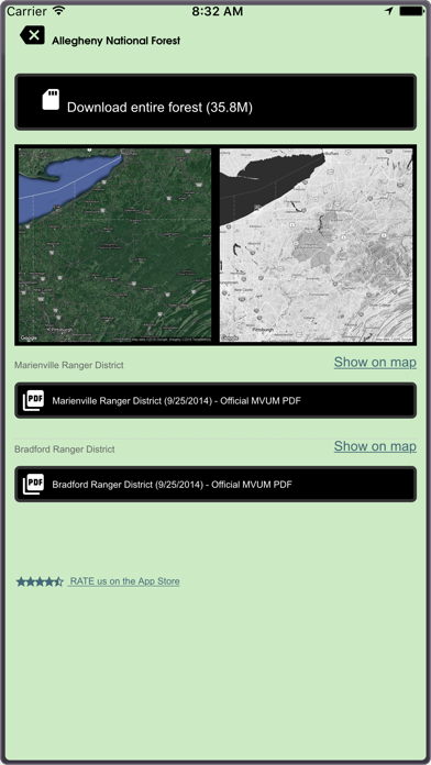
OFFROAD ATLAS allows you to safely explore our National Forest land, even offline. The app shows your GPS location on our seamless Motor Vehicle Use Map (MVUM) to help you identify roads, stay on trails, obey use classifications, and navigate alternative routes in and out of the forest. We also offer quick access to the official MVUM PDFs.
What is a MVUM? It is a map that shows where you can legally operate a motor vehicle on National Forest land. OFFROAD ATLAS uses your phone’s GPS to show your location on our seamless map. We combine the MVUM with other data such as local roads and our map is easily downloaded for offline use.
You may browse the map while you have wifi or cell service and OFFROAD ATLAS will automatically download any of the areas you view for offline use when you don't have network access. You may also bulk download any of the areas you plan on visiting.
Always have as much information as possible, please consult the published (printable) PDF Motor Vehicle Use Maps available for any individual forests you plan on visiting to get the latest dispersed camping allowances, seasonal closures, and any other relevant information. As always, be careful, many trails and roads are not suitable for passenger car travel. Some are only traversable in the most capable off road vehicles by the most experienced drivers.
Have fun, be safe, and respect the trails.
OFFROAD ATLAS makes no warranty, expressed or implied, including the warranties of merchantability and fitness for a particular purpose, nor assumes any legal liability or responsibility for the accuracy, reliability, completeness or utility of these geospatial data, or for the improper or incorrect use of these geospatial data. These geospatial data and related maps or graphics are not legal documents and are not intended to be used as such. The data and maps may not be used to determine title, ownership, legal descriptions or boundaries, legal jurisdiction, or restrictions that may be in place on either public or private land. Natural hazards may or may not be depicted on the data and maps, and land users should exercise due caution. The data are dynamic and may change over time. The user is responsible to verify the limitations of the geospatial data and to use the data accordingly.
The OFFROAD ATLAS map service depicts Forest Service roads and trails that are designated for motor vehicle use under the official U.S. Government Code of Federal Regulations for identifying designated roads and trails (36 CFR 212.56). Road and Trail MVUM. Additional roads, such as highways, county roads or public roads, are included for mapping purposes. This map service shows the specific types of motorized vehicles allowed on the designated routes and seasonal designation. Data used in this map service are designed to be consistent with the MVUM (Motor Vehicle Use Map). The road and trail data are compiled from the GIS Data Dictionary data and Infra tabular data that the U.S. Forest Service administrative units have prepared for the creation of their MVUMs. This data is published and refreshed on a unit by unit basis as needed and approved by the individual units in order to stay in sync and consistent with the published MVUMs. Interstate, Highway, Other Major Non USFS Roads, and Historic roads for reference are for mapping purposes only and should not be relied upon for their availability for motorized use.
U.S. Geological Survey National Hydrography Dataset, U.S. Department of Transportation Federal Highway Administration HPMS, and various USDA Forest Service datasets used in compiling this information.
{{descriptionMoreText}}
Comments (0)
{{commentText.length}}/{{maxCommentText}}
{{commentError}}{{commentUserError}}
-
{{comment.commentUser.substring(0, 1)}}By {{comment.commentUser}}{{comment.commentDateString}}
Category Top
apps
- Google Play
- App Store


More Apps


