


 Art & Design
 Auto & Vehicles
 Beauty
 Business
 Education
 Entertainment
 Finance
 Food & Drink
 Health & Fitness
 House & Home
 Libraries & Demo
 Lifestyle
 Maps & Navigation
 Medical
 Music & Audio
 Parenting
 Personalization
 Photography
 Productivity
 Shopping
 Social
 Sports
 Tools
Tools Travel & Local
 Video Players
 Weather
 Family


 NP Maps
OS :
Version :7.2
Size :50.72Mb
Updated :Mar 24,2019
Developer :Delcartes LLC
 Ask AI
 Ask AI
Pros and Cons from users' feedback
Based on the reviews, here are three pros and three cons of the Np Maps app:
**Pros:**
1. Accurate mapping with clear labels, helpful for navigation and route planning.
2. Offline access allows for smooth use even without internet connectivity.
3. Customizable with various themes and display options for personal preference.
**Cons:**
1. Some users find the app's design cluttered and overwhelming, lacking simplicity.
2. Limited features compared to more popular mapping apps, such as Google Maps.
3. Occasional errors in map data, resulting in incorrect directions or missing places.
Note: The pros and cons are based on a general summary of the reviews and may not reflect the opinions of every user.
App
Downloads
<
>

App
Survey
-
Why do you uninstall an app?
-
Whether the app response speed affects the experience?
-
Does the frequency of application notifications affect the experience?
-
Do you think the aesthetics of the interface UI affects the experience?
Description
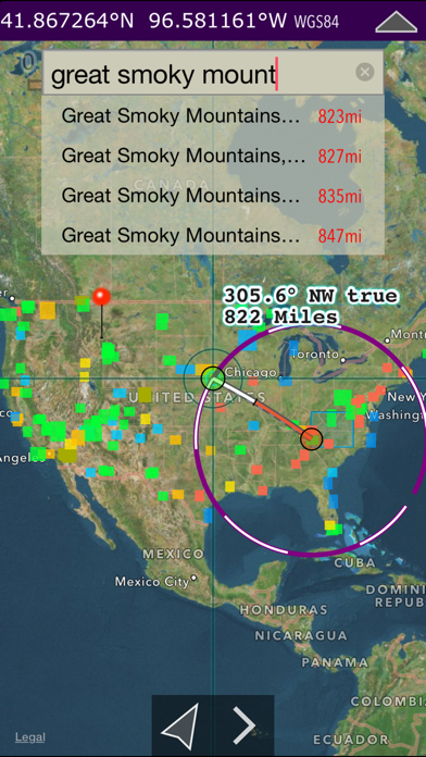
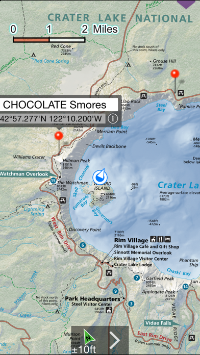
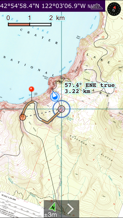
Download official National Park Service maps and USGS topos on your IOS devices for GPS** and offline use!
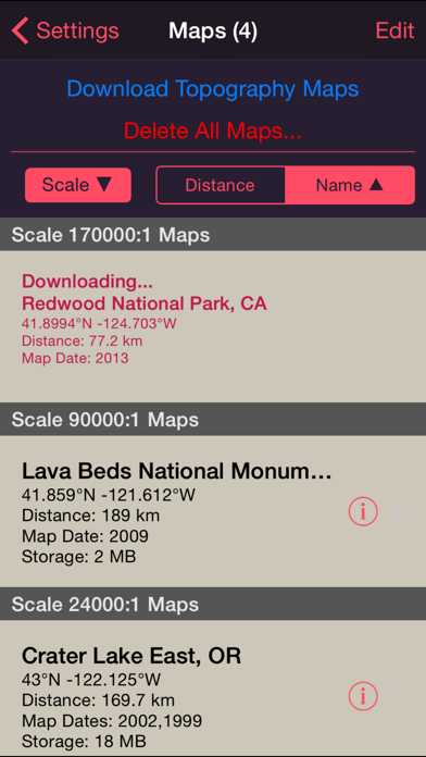
NP Maps app offers 150 NPS park, recreation area, monument and preserve maps for download and 60,000+ official U.S. Geological Survey topographic maps covering all of the USA and Island Territories.*
Have maps anytime, anywhere, for your travels to all parks in the USA. Because many of these wilderness regions have no data service, download maps while online so you can enjoy using this app as it was intended: no internet connection.
Logical and intuitive to use. Maps are geospatially integrated with Apple Maps for a familiar interface. An visual catalog of map footprints indexes an extensive library covering all the USA for you to select maps to install all with a simple touch along your planned route of travel.
Purchase a subscription for unlimited map downloading. A subscription stops ads and doesn't auto-renew. The first few map download are complementary.
Features:
• Downloads from a library of over 67,000 maps from NPS, USGS, US Forest service.
• Full rendering high resolution maps
• Shows your current GPS location & elevation**
• Powerful geocode search of worldwide geographic features (online)
• Waypoints with AR finder
• Route path creation
• Track path GPS location recording**
• Ruler with line + path measuring
• Full app use while maps download
• Footprint index with quadrangle names
• Multi-datum coordinates
• Automatic map download for location
• Statute, Nautical, Feet, Meter and km
• MGRS, UTM and geodetic Latitude and Longitude coordinates.
• Import and GPX files (and KML place marks)
• Integrated help manual
• Email and SMS text waypoints, tracks and routes as GPX, with subscription purchase.
Some park maps available for download,
National Parks:
Acadia
Arches
Badlands
Big Bend
Biscayne
Black Canyon of the Gunnison
Bryce Canyon
Canyonlands
Capitol Reef
Carlsbad Caverns
Channel Islands
Crater Lake
Cuyahoga Valley
Death Valley
Denali
Everglades
Gates of the Arctic
Glacier Bay
Glacier
Grand Canyon
Grand Teton
Great Basin
Great Sand Dunes
Great Smoky Mountains
Guadalupe Mountains
Haleakala
Hot Springs
Isle Royale
Joshua Tree
Katmai
Kenai Fjords
Kobuk Valley
Lassen Volcanic
Mammoth Cave
Mesa Verde
Mount Rainier
North Cascades
Olympic
Petrified Forest
Pinnacles
Point Reyes National Seashore
Redwood
Rocky Mountain
Saguaro
Sequoia and Kings Canyons
Shenandoah
Theodore Roosevelt
Virgin Islands
Voyageurs
Wind Cave
Yellowstone
Yosemite
Zion
National Recreation Areas:
Amistad
Big South Fork Nat. River
Boston Harbor Islands
Chickasaw
Golden Gate
Lake Mead
Lake Meredith
Lake Roosevelt
Santa Monica Mountains
Whiskeytown Shasta-Trinity
National Monuments:
Aniakchak
Bandelier
Canyon De Chelly
Capulin Volcano
Craters of the Moon
Dinosaur
Devils Tower
Fort Pulaski
Grand Canyon - Parashant
Lava Beds
Mount Saint Helens
Natural Bridges
Organ Pipe Cactus
National Preserves & Reserves:
Big Cypress
Big Thicket
Catoctin Mountain Park
City of Rocks
Greenbelt Park
Mojave
National Historical Parks:
Antietam
Brown v. Board of Education
Cumberland Gap
Ebey's Landing
Fredericksburg and Spotsylvania
French Quarter
Gettysburg
Harpers Ferry
Herbert Hoover
Horseshoe Bend
Kennesaw Mountain
Kings Mnt
Lowell
Manassas
Minute Man
Monocacy
Morristown
Richmond
San Antonio Missions
Saratoga
Valley Forge
Vicksburg
National Seashores, Lakeshores and Scenic Rivers:
Apostle Islands
Assateague Is.
Canaveral
Cape Hatteras
Cumberland Is.
Indiana Dunes
Missouri
New River Gorge
Niobrara
Ozark
Padre Is.
Sleeping Bear Dunes
St. Croix
Nat. Parkways & Trails:
Blue Ridge Parkway
George Wash. Mem. Parkway
Potomac Heritage Nat. Scenic Tr.
* Not preloaded with maps. WiFi recommended. Downloading queue does cap at around 25 maps.
** Continued use of GPS running in the background can dramatically decrease battery life. Location feature may not function on iPod and wifi-only iPad devices without GPS hardware.
{{descriptionMoreText}}
Comments (0)
{{commentText.length}}/{{maxCommentText}}
{{commentError}}{{commentUserError}}
-
{{comment.commentUser.substring(0, 1)}}By {{comment.commentUser}}{{comment.commentDateString}}
Developer apps


Category Top
apps
- Google Play
- App Store


More Apps


