


 Art & Design
 Auto & Vehicles
 Beauty
 Business
 Education
 Entertainment
 Finance
 Food & Drink
 Health & Fitness
 House & Home
 Libraries & Demo
 Lifestyle
 Maps & Navigation
 Medical
 Music & Audio
 Parenting
 Personalization
 Photography
 Productivity
 Shopping
 Social
 Sports
 Tools
Tools Travel & Local
 Video Players
 Weather
 Family


 LiveWeather Map
OS :
Version :1.1
Size :7.13Mb
Updated :Dec 9,2021
Developer :Manuel Oehme
 Ask AI
You can ask
the AI some questions about the app
Here are three topics that users might discuss about the Liveweather Map app, turned into questions for you:
1. How does the app's radar feature help you track severe weather events in real-time?
2. Can you customize the app's map settings to suit your specific weather monitoring needs?
3. Are the app's weather forecasts accurate and reliable, or do they often differ from other sources?
 Ask AI
Pros and Cons from users' feedback
Based on the users' reviews of the Liveweather Map app, here are three cons and pros in English, limited to 15 words each:
**Cons:**
1. "App frequently crashes and requires constant restarts, frustrating to use."
2. "Weather forecasts are inaccurate and don't match actual conditions."
3. "No option for customizing map settings, such as displaying multiple weather layers."
**Pros:**
1. "Intuitive design makes it easy to navigate and view weather details."
2. "Provides detailed forecasts and maps for multiple locations worldwide."
3. "App is free from ads and clutter, providing a clean user experience."
Note: The reviews are subject to change, and this conclusion is based on the current reviews at the time of my knowledge cutoff.
App
Downloads
<
>

App
Survey
-
Where do you get the new APP
-
Application interactivity Does it affect the experience?
-
Do you think the payment of application features affects the experience?
-
Does the feedback of the application affect the experience?
Description
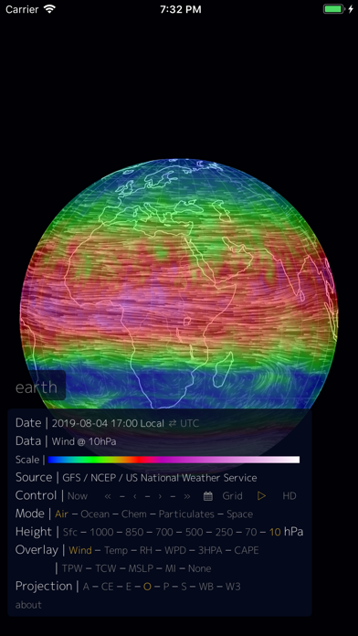
-- This is an inofficial iOS App port of the Nullschool Earth Project by Cameron Beccario --
A free open weather Map to show wind, weather and oceans conditions.
Height: Atmospheric pressure corresponds roughly to altitude several pressure layers are meteorologically interesting they show data assuming the earth is completely smooth note: 1 hectopascal (hPa) = 1 millibar (mb)
Surface - the "Surface" layer represents conditions at ground or water level this layer follows the contours of mountains, valleys, etc.
• 1000hPa ~100 m, near sea level conditions
• 850hPa ~1,500 m, planetary boundary, low
• 700hPa ~3,500 m, planetary boundary, high
• 500hPa ~5,000 m, vorticity
• 250hPa ~10,500 m, jet stream
• 70hPa ~17,500 m, stratosphere
• 10hPa ~26,500 m, even more stratosphere
Overlay: Show another dimension of data using color some overlays are valid at a specific height while others are valid for the entire thickness of the atmosphere
• Wind - wind speed at specified height
• Temp - temperature at specified height
• RH - relative humidity at specified height
• WPD - Instantaneous Wind Power Density. Measure of power available in the wind: ½ρv3, where ρ is air density and v is wind velocity
• TPW - Total Precipitable Water. Total amount of water in a column of air stretching from ground to space
• TCW - Total Cloud Water. Total amount of water in clouds in a column of air from ground to space
• 3HPA - 3-hour Precipitation Accumulation. Amount of precipitation over the next three hours
• CAPE - Convective Available Potential Energy from Surface. Indicates the buoyancy of air, a measure of atmospheric instability and predictor of severe weather
• MSLP - Mean Sea Level Pressure. Air pressure reduced to sea level
• MI - Misery Index. Perceived air temperature as combination of heat index and wind chill
• SST - Sea Surface Temperature. Temperature of the ocean surface
• SSTA - Sea Surface Temperature Anomaly. Difference in ocean temperature from daily average during years 1981-2011
• HTSGW - Significant Wave Height. Roughly equal to mean wave height as estimated by a "trained observer"
• COsc - Carbon Monoxide Surface Concentration. The fraction of carbon monoxide present in air at the earth's surface
• CO2sc - Carbon Dioxide Surface Concentration. The fraction of carbon dioxide present in air at the earth's surface
• SO2sm - Sulfur Dioxide Surface Mass. Amount of sulfur dioxide in the air near the earth's surface
• DUex - Dust Extinction. The aerosol optical thickness (AOT) of light at 550 nm due to dust
• SO4ex - Sulfate Extinction. The aerosol optical thickness (AOT) of light at 550 nm due to sulfate
Projection :
• Atlantis (A)
• Azimuthal Equidistant (AE)
• Conic Equidistant (CE)
• Equirectangular (E)
• Orthographic (O)
• Patterson (P)
• Stereographic (S)
• Waterman Butterfly (WB)
• Winkel Tripel (W3)
Longitude :
• Longitude (-360 - 360). Example: -214.68
Latitude :
• Latitude (-360 - 360). Example: 14.2
Zoom :
• Zoom (0-3000)
{{descriptionMoreText}}
Comments (0)
{{commentText.length}}/{{maxCommentText}}
{{commentError}}{{commentUserError}}
-
{{comment.commentUser.substring(0, 1)}}By {{comment.commentUser}}{{comment.commentDateString}}
Category Top
apps
- Google Play
- App Store


More Apps


