


 Art & Design
 Auto & Vehicles
 Beauty
 Business
 Education
 Entertainment
 Finance
 Food & Drink
 Health & Fitness
 House & Home
 Libraries & Demo
 Lifestyle
 Maps & Navigation
 Medical
 Music & Audio
 Parenting
 Personalization
 Photography
 Productivity
 Shopping
 Social
 Sports
 Tools
Tools Travel & Local
 Video Players
 Weather
 Family


 iNavX: Marine Navigation
OS :
Version :5.6.17
Size :292.59Mb
Updated :Sep 29,2022
Developer :NavX Studios LLC
 Ask AI
You can ask
the AI some questions about the app
Here are three topics that users may discuss about the InavX Marine Navigation app, turned into questions:
1. What features do you like most about InavX's chart plotting and navigation capabilities?
2. How do you find the accuracy of InavX's GPS and electronic compass in real-world use?
3. Have you experienced any issues with InavX's compatibility with your specific boat or marine device?
 Ask AI
Pros and Cons from users' feedback
I'd be happy to help you with that! After analyzing the user reviews on the Apple App Store, here are three pros and three cons of the InavX Marine Navigation app:
Pros:
1. Accurate navigation: Users praise the app's accurate charting and navigation features, making it easy to find their way.
2. User-friendly interface: Reviewers appreciate the app's intuitive design, making it simple to use even for those new to marine navigation.
3. Real-time updates: Users appreciate the app's ability to provide real-time updates on weather, tides, and other important marine data.
Cons:
1. Limited coverage: Some users report that the app's chart coverage is limited, making it difficult to navigate in certain areas.
2. Glitches and bugs: A few reviewers mention experiencing glitches and
App
Downloads
<
>
App
Survey
-
Application interactivity Does it affect the experience?
-
Whether the application ad recommendation affects the experience?
-
The degree of memory and power consumption Does it affect the experience?
-
Why do you uninstall an app?
Description
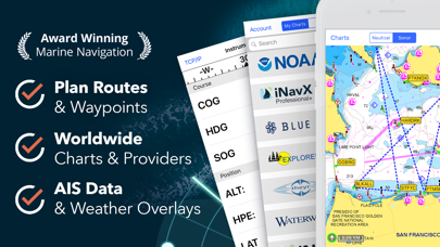
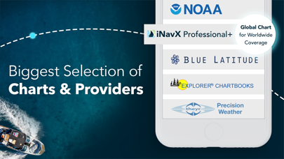
Marine navigation is made easy with iNavX - the world's #1 handheld Chartplotter. Access marine charts, maps, weather, AIS and more!
iNavX is the only app to give you complete worldwide chart coverage, from all your favorite charts providers, including the ALL NEW iNavX Professional+ Global Chart! Fully enabled with one-touch access, iNavX gives users access to the broadest set of marine charts and maps from multiple providers including:
• iNavX Professional+ Charts
• Blue Latitude
• Explorer
• Theyr Weather
• Waterway Guide
• … and more
How does iNavX take handheld marine navigation to the next level?
• Sailors - Plan sailing routes with waypoint and route management. Get proactive sail management with GRIB weather forecasts and then keep watch with AIS overlays and integration with your onboard systems. Plus, you can remember your great sailing locations by geotagging photos.
• Boaters - Stay up to date on boating conditions with forecasts that include currents, winds, and swells. Manage your boating equipment with nautical instrument integration and then save great boating routes to share with the track log.
• Anglers - Discover new fishing spots by scouting out holes and inlets. Locate the best fishing conditions by identifying cold fronts and save your best fishing spots with unlimited markers.
Advanced features - iNavX is the most feature rich app available for all sailing and boating needs at a great price:
Advanced Chart Plotter
• Plot your position in real-time using your device's built-in GPS
• Pan, zoom, and rotate charts (including course up)
• Print detailed charts to use in combination with the app
Advanced Navigation
• Create waypoints and plan routes to navigate between them
• Track log allows you to record your route
• Import/export data in KML (Google Earth) or GPX format
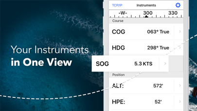
Advanced Instrumentation
• Supports NMEA data over TCP/IP (using Wifi)
• Integrates with external GPS, AIS receivers & transponders
• Connect nautical instruments: Depth, Speed, Wind, Engine, Batteries, etc.
Essential Toolkit
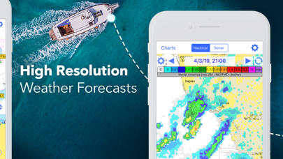
• GRIB weather forecast
• Tides/currents
• Anchor alarm
• AIS integration
• Port/navaid search
Download iNavX TODAY and automatically receive a complimentary copy of the official and up-to-date high-resolution NOAA RNC United States marine raster charts.
REVIEWS
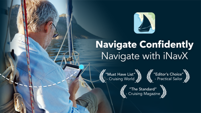
“iNavX is the original and still one of the best navigation apps.”
– Practical Sailor
“The most full-featured navigation app around and viewed by many as the standard”
– Sail Magazine
"The #1 recommended marine charting app"
- iMarineApps
iNavX is Compatible with: C-MAP, Theyr Weather, Waterway Guide, AIS, Brookhouse, DigitalYacht, ShipModul, vYacht, Vesper Marine, NMEA 2000, Chetco and more.
NEW CHART STORE
Purchase all your favorite charts. Chart subscriptions vary by chart and provider from $9.99 to $199.99 annually, charged to your iTunes Account, which will automatically renew unless cancelled at least 24 hours before the end of the current period. Auto-renew can be turned off anytime by going to your Account Settings in iTunes after purchase. No cancellation of the current subscription is allowed during active subscription period.
NOTE: Continued use of GPS running in the background can dramatically decrease battery life.
MORE INFO
Website: http://inavx.com/
User's Guide: http://inavx.com/help/
Terms of Use: http://inavx.com/terms
Privacy Policy: http://inavx.com/privacy
{{descriptionMoreText}}
Comments (2)
{{commentText.length}}/{{maxCommentText}}
{{commentError}}{{commentUserError}}
-
{{comment.commentUser.substring(0, 1)}}By {{comment.commentUser}}{{comment.commentDateString}}
-
jBy jgiermannMay 19,2019
-
PBy Pytheas5Sep 30,2017
Category Top
apps
- Google Play
- App Store


More Apps


