


 Art & Design
 Auto & Vehicles
 Beauty
 Business
 Education
 Entertainment
 Finance
 Food & Drink
 Health & Fitness
 House & Home
 Libraries & Demo
 Maps & Navigation
 Medical
 Music & Audio
 Parenting
 Personalization
 Photography
 Productivity
 Shopping
 Social
 Sports
 Tools
Tools Travel & Local
 Video Players
 Weather
 Family


 Guru Maps Pro
OS :
Version :5.1.3
Size :
Updated :Nov 28,2022
Developer :Evgen Bodunov
 Ask AI
You can ask
the AI some questions about the app
Based on online discussions about the GalileoPro app, here are three topics and corresponding questions:
Topic 1: Features
What are the most useful features of the GalileoPro app according to users?
Topic 2: GPS Accuracy
Does the app provide accurate GPS directions, and if not, what are the common complaints?
Topic 3: Integration with Other Devices
Can the GalileoPro app seamlessly connect with other devices, such as smartphones or smartwatches, or are there any compatibility issues?
 Ask AI
Pros and Cons from users' feedback
Based on the users' reviews of the Galileo Pro app, here are three cons and pros in English, with 15 words limited for each item:
**Pros:**
1. Accurate navigation and mapping technology provides reliable directions and insights.
2. User-friendly interface makes it easy to navigate and find desired locations quickly.
3. Optional offline mode allows for continued use even without internet connectivity.
**Cons:**
1. Frequent software updates require restarting app, causing inconvenience and disruption.
2. Limited street view feature accuracy, sometimes not updated to recent changes.
3. Occasional crashes when switching between maps, requiring app restart to recover.
Please note that these are based on the general trends and patterns in the users' reviews, and individual experiences may vary.
App
Downloads
<
>

App
Survey
-
Application technology innovation Does it affect the experience?
-
Why do you uninstall an app?
-
Does the feedback of the application affect the experience?
-
Do you think the payment of application features affects the experience?
Description
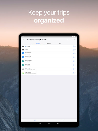
Detailed offline maps with turn-by-turn navigation for the great outdoors: hiking, biking and off-roading. Plan your trips in advance, record your GPS tracks realtime on a map and create collections of your favorite places or places you want to visit.
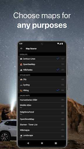
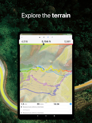
OFFLINE MAPS
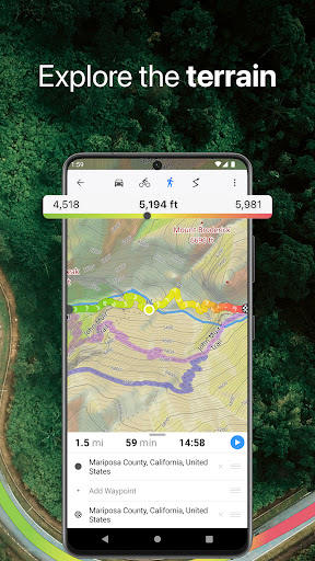
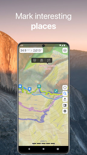
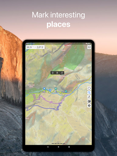
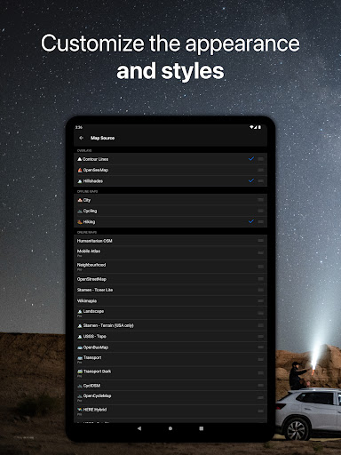
• Detailed maps covering the entire world & based on OpenStreetMap data.
• Maps updated monthly with the most-recent fixes and additions.
• Adjustable font size of the labels on the map for better readability.
• Multiple custom map layers can be shown above the base map (GeoJSON support).
• Hillshades and contour lines for relief visualisation.
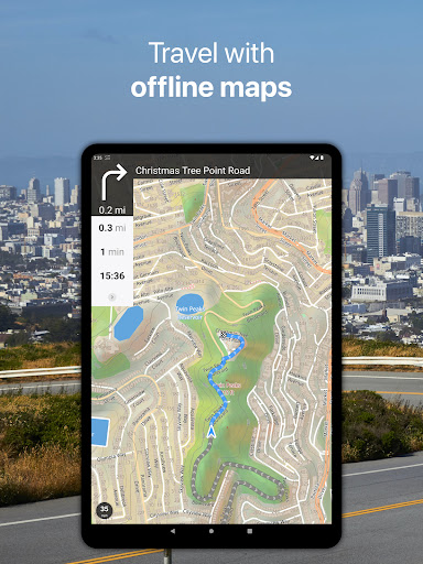
OFFLINE NAVIGATION
• Turn-by-turn driving directions with alternative routes.
• Voice instructions while navigating available in 9 languages.
• Routes for Driving/Cycling/Walking/Shortest Distance.
• Automatic rerouting gets you back along your way, even offline.
• Supports intermediate points on your itinerary.
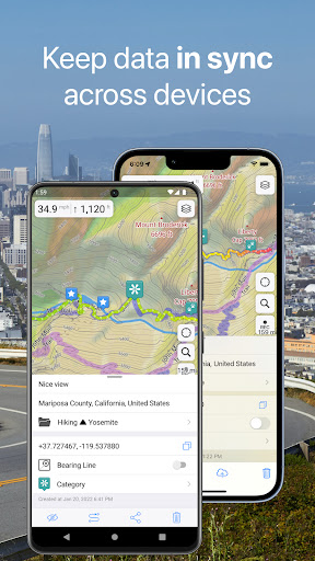
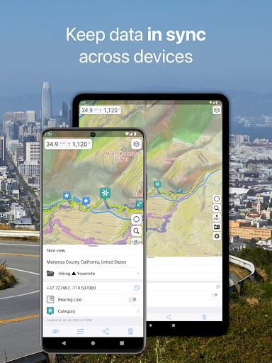
SYNCHRONIZATION
• Seamless sync your data across multiple iOS/Android devices as long as they are authorized with the same account.
• All the data such as saved places, recorded GPS tracks and created routes will be synced on all your devices on both OS platforms.
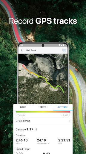
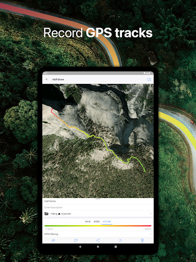
GPS TRACKS
• Record your trips even when the app is in the background.
• Monitor your real-time speed, distance, and time traveled, as well as altitude right on the map during the trip.
• Choose from seven solid track colors, or altitude and speed gradients.
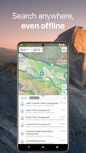
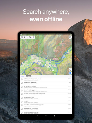
OFFLINE SEARCH
• Incredibly fast – results appear instantly as you type.
• Search in a variety of ways – by address, object name, category, or even by GPS coordinates.
• Searches simultaneously in multiple languages, making searching easier than ever.
SUPPORTED FILE FORMATS:
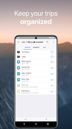
.GPX, .KML, .KMZ - for GPS-tracks, bookmarks, routes or whole travel collections.
.MS, .XML - for custom map sources,
.SQLiteDB, .MBTiles - for offline raster maps.
.GeoJSON - for overlays.
Terms of Service and Privacy Policy: https://gurumaps.app/terms_of_service.html
Continued use of GPS running in the background can decrease battery life.
OFFLINE MAPS
• Detailed maps covering the entire world & based on OpenStreetMap data.
• Maps updated monthly with the most-recent fixes and additions.
• Adjustable font size of the labels on the map for better readability.
• Multiple custom map layers can be shown above the base map (GeoJSON support).
• Hillshades and contour lines for relief visualisation.
OFFLINE NAVIGATION
• Turn-by-turn driving directions with alternative routes.
• Voice instructions while navigating available in 9 languages.
• Routes for Driving/Cycling/Walking/Shortest Distance.
• Automatic rerouting gets you back along your way, even offline.
• Supports intermediate points on your itinerary.
SYNCHRONIZATION
• Seamless sync your data across multiple iOS/Android devices as long as they are authorized with the same account.
• All the data such as saved places, recorded GPS tracks and created routes will be synced on all your devices on both OS platforms.
GPS TRACKS
• Record your trips even when the app is in the background.
• Monitor your real-time speed, distance, and time traveled, as well as altitude right on the map during the trip.
• Choose from seven solid track colors, or altitude and speed gradients.
OFFLINE SEARCH
• Incredibly fast – results appear instantly as you type.
• Search in a variety of ways – by address, object name, category, or even by GPS coordinates.
• Searches simultaneously in multiple languages, making searching easier than ever.
SUPPORTED FILE FORMATS:
.GPX, .KML, .KMZ - for GPS-tracks, bookmarks, routes or whole travel collections.
.MS, .XML - for custom map sources,
.SQLiteDB, .MBTiles - for offline raster maps.
.GeoJSON - for overlays.
Terms of Service and Privacy Policy: https://gurumaps.app/terms_of_service.html
Continued use of GPS running in the background can decrease battery life.
{{descriptionMoreText}}
Comments (0)
{{commentText.length}}/{{maxCommentText}}
{{commentError}}{{commentUserError}}
-
{{comment.commentUser.substring(0, 1)}}By {{comment.commentUser}}{{comment.commentDateString}}


Category Top
apps
- Google Play
- App Store
4
5
Lifestyle
 Daily Diary:Journal with Lock
 Life360: Find Family & Friends
 Pinterest
 T-Mobile Tuesdays
 Frecuencia
Photography
 Picsart AI Photo Editor, Video
 Amazon Photos
 Time Warp Scan - Face Scanner
 ToonApp: Cartoon Photo Editor
 Pixelup - AI Photo Enhancer


More Apps


