


 Art & Design
 Auto & Vehicles
 Beauty
 Business
 Education
 Entertainment
 Finance
 Food & Drink
 Health & Fitness
 House & Home
 Libraries & Demo
 Lifestyle
 Maps & Navigation
 Medical
 Music & Audio
 Parenting
 Personalization
 Photography
 Productivity
 Shopping
 Social
 Sports
 Tools
Tools Travel & Local
 Video Players
 Weather
 Family


 GPX viewer
OS :
Version :1.3.6
Size :34.41Mb
Updated :Oct 8,2022
Developer :Jonathan Gander
 Ask AI
You can ask
the AI some questions about the app
Here are three topics that users may discuss about the GPX Viewer app, turned into questions for you:
1. How do you find the accuracy of the GPS tracking feature in GPX Viewer?
2. Are the map overlays and customization options in GPX Viewer sufficient for your needs?
3. Have you encountered any issues with file compatibility or data import/export in GPX Viewer?
 Ask AI
Pros and Cons from users' feedback
Based on the user reviews of the GPS Viewer app, here are three pros and cons:
**Pros:**
1. "Excellent app for GPS tracking and analysis. Easy to use and navigate."
2. "App is very intuitive and user-friendly, even for those new to GPS tracking."
3. "This app has saved me so much time and effort in reviewing GPS data, highly recommended!"
**Cons:**
1. "Sometimes crashes and loses data, frustrating and inconvenient."
2. "Lack of customization options can be limiting for some users."
3. "Exporting data can be slow and time-consuming, needs improvement."
App
Downloads
<
>


App
Survey
-
Have you ever thought of deleting them?
-
How much traffic the app consumes Does it affect the experience?
-
Does the feedback of the application affect the experience?
-
Whether the application ad recommendation affects the experience?
Description
Import your routes in GPX format (tracks or routes) into the application.
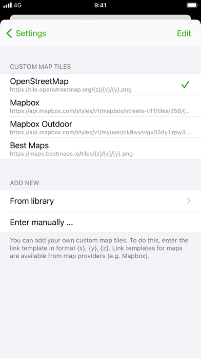
Display them on different preset maps (plan, satellite, OpenStreetMap, OpenTopoMap, Swisstopo, IGN) or on your own custom maps.
Display an elevation graph to evaluate their difficulty. And check out all of their information.
Follow your position along the route during your ride. You can also display points of interest from GPX.
All what you need to go hiking and follow your route. All for free and without ads. The only in-app purchases are tips for few other features, take a look.
Features details:
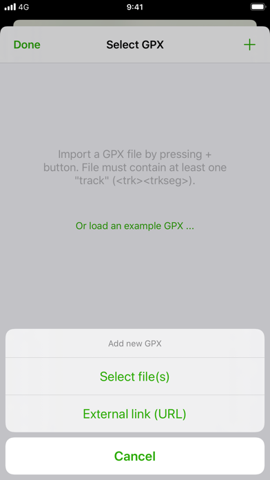
- Import of GPX files via file or web link
- Management of imported GPX (library)
- Display GPX track on the map (track and route)
- Several base maps: map, hybrid, satellite 3D, OpenStreetMap, OpenTopoMap, Swisstopo
- Possibility to set your own custom maps from a library or manually
- Possibility to download maps for offline use
- Displayed on the map: current position, start and end of the route, points of interest along the route, scale, route direction
- Choice of color and size of the route
- Locking of screen standby to better follow the route
- Map cache system
- Display of GPX details: name, description, longitudinal profile, elevation differences, distance, image gallery, link, points of interest
- Display details of a point of interest: name, description, image gallery, links
- Access to the route via Maps, Google Maps or Waze
- Sharing a GPX
- GPX editor
- Speedometer
Note: If the application cannot open a GPX file, contact me by sending me the file.
{{descriptionMoreText}}
Comments (1)
{{commentText.length}}/{{maxCommentText}}
{{commentError}}{{commentUserError}}
-
{{comment.commentUser.substring(0, 1)}}By {{comment.commentUser}}{{comment.commentDateString}}
-
sBy sj54689:4)$3:Apr 28,2021
Category Top
apps
- Google Play
- App Store


More Apps


