


 Art & Design
 Auto & Vehicles
 Beauty
 Business
 Education
 Entertainment
 Finance
 Food & Drink
 Health & Fitness
 House & Home
 Libraries & Demo
 Lifestyle
 Maps & Navigation
 Medical
 Music & Audio
 Parenting
 Personalization
 Photography
 Productivity
 Shopping
 Social
 Sports
 Tools
Tools Travel & Local
 Video Players
 Weather
 Family


 GPX Trail Tracker
OS :
Version :1.3.4
Size :13.90Mb
Updated :Mar 24,2019
Developer :murbit GmbH
 Ask AI
 Ask AI
Pros and Cons from users' feedback
I'd be happy to help you with that! After analyzing the user reviews on the App Store, here are three pros and three cons of the GPX Trail Tracker app:
Pros:
1. Accurate tracking: Users praise the app's ability to accurately track their hikes and trails, providing precise location data.
2. User-friendly interface: Reviewers find the app's interface easy to navigate, making it simple to plan and track their outdoor adventures.
3. Offline capabilities: Many users appreciate the app's ability to work offline, allowing them to track their routes even without cellular service.
Cons:
1. Limited route planning: Some users find the app's route planning features limited, making it difficult to customize their trails.
2. No real-time weather updates: Reviewers note that the app does not provide real-time weather
App
Downloads
<
>


App
Survey
-
The degree of memory and power consumption Does it affect the experience?
-
How do you feel about ads embedded in mobile applications?
-
Ease of use of the application Does it affect the experience?
-
How much time do you spend on app applications every day?
Description
GPX Tracker is a simple to use but powerful tool that helps you to track your ways. If you drive a car, biking or even outdoor on a walking or hiking tour, GPX Tracker will be tracing your geo data.
Once developed as a creator for XCode compatible GPX formatted files, the feature list is growing but it is still as simple to use.
Configuration
GPX Tracker has a simple configuration interface.
* Distance Filter - specifies the minimum distance between two way points in meters.
* Auto Stop - If you ever forget to turn off the recorder, don't mind. GPX Tracker figures out whenever you stop traveling and stops tracing your trip to save energy.
* Reminder - If this feature is turned on, you will receive a message whenever you stop by for a few minutes to remind you on stopping the track tracing.
Trip Tracking
The main screen has a start/stop button. Simply press this button once for tracing a new trip and a second time whenever you want to stop recording data.
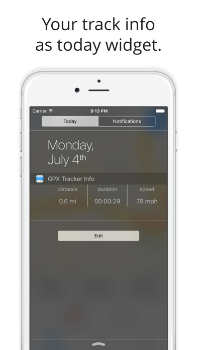
On the top of the screen, you will see the traveled miles or kilometers depending on your locale system configuration.
With the menu bar item on the right side you can choose different user tracking modes for the maps.
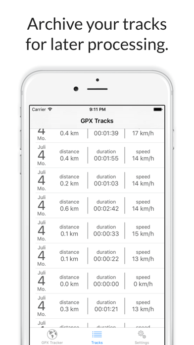
Tracks
The Tracks screen provides a list of tracks recorded. The will show the date and time of recording, the duration of the trip and its distance.
If you tap on one of the trips, it will be displayed on a map. From there on, you can press the menu bar item on the right side to choose an export format and send the generated
file by email.
Back in the Tracks screen, you can easily delete a recorded track by swiping the desired item from the right to the left.
Track Export Formats
There are two output formats available.
* XCode compatible "wpt"-tag based GPX files. This format can be used for the iOS Simulator by added the generated gpx file to an XCode iOS Project.
* Common GPX "trk"-tag based format. The track will consist of a collection of "trkpt" tags within a "trk" element. This format should be fine for any application that processes gpx tracks.
GPX Tracker is free but ad supported.
Please note: Continued use of GPS running in the background can dramatically decrease battery life. GPS will be stopped automatically, as soon as you stop recording a track.
{{descriptionMoreText}}
Comments (0)
{{commentText.length}}/{{maxCommentText}}
{{commentError}}{{commentUserError}}
-
{{comment.commentUser.substring(0, 1)}}By {{comment.commentUser}}{{comment.commentDateString}}
Category Top
apps
- Google Play
- App Store


More Apps


