


 Art & Design
 Auto & Vehicles
 Beauty
 Business
 Education
 Entertainment
 Finance
 Food & Drink
 Health & Fitness
 House & Home
 Libraries & Demo
 Lifestyle
 Maps & Navigation
 Medical
 Music & Audio
 Parenting
 Personalization
 Photography
 Productivity
 Shopping
 Social
 Sports
 Tools
Tools Travel & Local
 Video Players
 Weather
 Family


 DroneDeploy Flight App
OS :
Version :4.118.0
Size :332.34Mb
Updated :Dec 12,2022
Developer :DroneDeploy
 Ask AI
You can ask
the AI some questions about the app
Here are three topics that users might discuss about the Dronedeploy Flight App, turned into questions:
1. What are the most significant improvements you're expecting from the app's aerial mapping features?
2. How do you plan to use the app's flight planning and management tools for your drone operations?
3. What type of drone do you currently use, and how does it integrate with the Dronedeploy Flight App?
 Ask AI
Pros and Cons from users' feedback
Based on the user reviews of the DroneDeploy Flight App, here are three cons and three pros:
**Cons:**
1. "Frequent crashes and freezing issues while in flight, causing frustration and loss of data." (15 words)
2. "Some features, such as obstacle avoidance, not available on all drone models, limiting functionality." (15 words)
3. "Customer support response times can be slow, leaving users waiting for assistance." (15 words)
**Pros:**
1. "Intuitive interface makes it easy for beginners to learn and start flying quickly." (15 words)
2. "High-quality video and photo capture capabilities, with customizable settings and processing." (15 words)
3. "Robust offline mode allows for flights and data capture even without internet connection." (15 words)
Please note that these summaries are based on a snapshot of the user reviews and may not reflect the complete range of opinions on the app.
App
Downloads
<
>

App
Survey
-
Does the update frequency of the application affect the experience?
-
Why do you uninstall an app?
-
Where do you get the new APP
-
What is your Mobile System?
Description
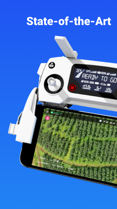
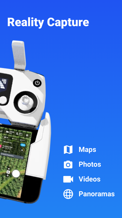
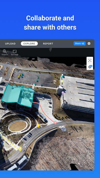
The free DroneDeploy app is the leading software for drones with millions of flights flown by over 100,000 pilots!
FLIGHT APP
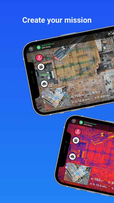
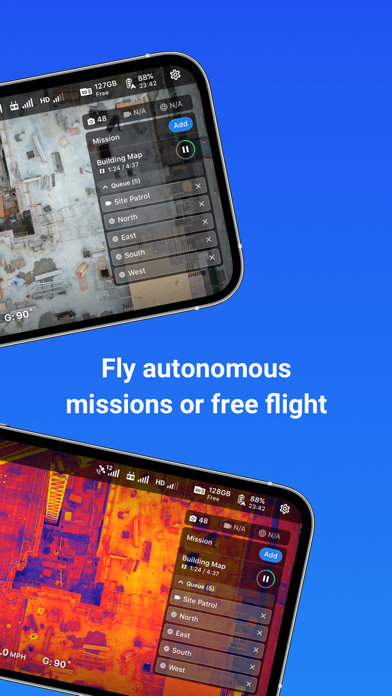
Download the DroneDeploy app to upgrade your drone with autonomous and free flight capabilities for automated capture in just a few taps. Your drone will fly itself! Anyone can fly with DroneDeploy.
Create missions from anywhere using the desktop or mobile app. Capture and share high-quality interactive 2D maps, 3D models, photos, videos, panoramas, roof reports, thermal scans, and more directly from your mobile device. DroneDeploy is the only flight app that provides instant offline maps without hours of processing time using Live Map technology.
DRONE PLATFORM
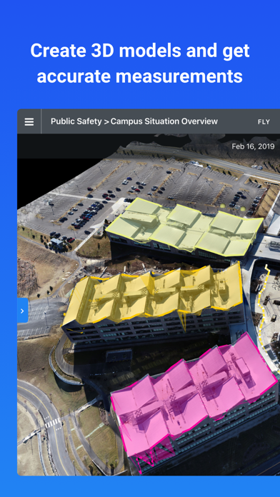
Upload your data to the DroneDeploy platform for professional and Enterprise grade aerial analytics and data processing. Analyze realistic 3D models, thermal maps, elevation maps, surveys and plant health visualizations. Annotate, inspect, and share directly with others from within the app. Even manage a fleet of drones and pilots with DroneDeploy Fleet Management. DroneDeploy has everything you need to create a smart drone program for any organization.
Want more? Extend DroneDeploy’s capabilities with over 80 apps available for install within DroneDeploy’s App Market, including AirMap for instant LAANC authorizations.
DroneDeploy is trusted by the world's largest companies in Construction, Solar, Energy, Agriculture, Surveying, Mining, Insurance, Inspection and more. Over 100 million acres have been mapped by DroneDeploy in more than 180 countries.
We're on a mission to make the power of aerial data accessible and productive for everyone.
DRONE SUPPORT
• Mavic 2 Pro / Zoom / Enterprise / Dual (thermal)
• Mavic Pro
• Mavic Air
• Mavic Air 2
• DJI Air 2S
• Phantom 4 Pro V1 / V2
• Phantom 4
• Inspire 2
• Matrice 200 / 210 / 210 RTK V1 / V2
• Matrice 300 RTK
• Matrice 600
• Matrice 100
• Skydio 2
• Skydio 2+
Not Compatible with the Following Hardware:
• DJI Spark
• DJI Mavic Mini
• CrystalSky Monitor and CrystalSky Integrated Display
HIGHLIGHTS
• Easily plan and schedule repeatable flights
• Fly and capture massive areas
• Disable auto-flight with a single tap
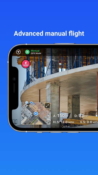
• Includes a full featured manual flight mode
• Film professional quality video hands-free
• Create automated spherical panoramas
• Record all your flight logs in one place
• Measure elevation, distance, volumes, surface area, and roof geometry (roof reports)
• Quickly create survey-grade maps and models with ground control points
• Collaborate with a team through shared maps, annotations, and comments
• Wirelessly upload images from the drone
• Export data in the format you need - JPG, Geotiff, OBJ, XYZ, LAS
• Explore Orthomosaic, NDVI, VARI, Digital Elevation Maps and 3D models
- - -
Find out more at www.dronedeploy.com
Please join us in improving and discussing the app at http://forum.dronedeploy.com
{{descriptionMoreText}}
Comments (3)
{{commentText.length}}/{{maxCommentText}}
{{commentError}}{{commentUserError}}
-
{{comment.commentUser.substring(0, 1)}}By {{comment.commentUser}}{{comment.commentDateString}}
-
hBy hasbisetiarahmanAug 3,2022
-
DBy Deddy DoyadoFeb 20,2022
-
aBy ari1@3Jul 17,2022
Category Top
apps
- Google Play
- App Store


More Apps


